A Late Ordovician sea–level curve for the Central Oslo Region: implications for Ashgill correlations
Arne Thorshøj Nielsen1 and David A.T. Harper1
1 Geological Museum, University of Copenhagen, Øster Voldgade 5–7, DK–1350 Copenhagen, Denmark. E–mail:arnet@savik.geomus.ku.dk / dharper@savik.geomus.ku.dk
Key words: Sea level changes. Sequence stratigraphy. Ashgill. Upper Ordovician. Oslo Region.
Introduction
The construction of regional sea–level curves provides a powerful tool to effect intra–provincial correlations. The analysis of sea–level fluctuations can, however, also aid the development of bio– and lithofacies models and help predict both short and long–term environmental change. The Oslo Region is one of the classic areas of Ordovician geology with abundant and diverse fossils developed across a wide range of facies. A modern lithostratigraphy is available for the region (Owen et al., 1990); that together with a robust biostratigraphy based on nearly 200 years of research provides a frame for the further investigation of biotic and environmental change. The well–exposed and fossiliferous rocks of the region provide an ideal opportunity to develop a sequence stratigraphy, particularly in the variable lithofacies of the Upper Ordovician. A model involving five major drowning events, the Linearis–1, Spannslokket, Husbergøya, Langøyene and Sælabonn, is outlined for the uppermost Caradoc–Ashgill deeper–water facies of the central Oslo Region. Extrapolation of the model north and west to the Ringerike, Hadeland and Mjøsa districts has provided a modified template for upper Ordovician correlations within and possibly outwith the region.
Caradoc – Ashgill lithofacies across the Oslo Region
The Caradoc–Ashgill successions of the Oslo Region were deposited in a distal foreland basin adjacent to the developing Scandinavian Caledonides (Bruton and Harper, 1988). The Oslo successions are thus relatively thicker than those deposited in Central Southern Sweden and the East Baltic region. Nevertheless, the net accumulation rates were very low with an average of 8 mm/1000 yrs during the Llanvirn–Caradoc, increasing to 35 mm/1000 yrs during the Ashgill (Oslo–Asker District). The latter rates anticipated the more proximal foreland conditions that developed during the Early Silurian. The Oslo Region was largely unaffected by tectonism during the Ordovician, although fault–controlled differential subsidence has been suggested by some authors (e.g., Bockelie, 1978; Stanistreet, 1983; Brenchley and Newall, 1975; Brenchley et al., 1997). In addition, the passage of foreland bulges has been inferred for the late Arenig (Nielsen, unpublished data) and the Llandovery (Baarli, 1990). The Ordovician of the central Oslo Region is about 450 m thick of which the Ashgill succession accounts for about 200 m. Farther northwest the thickness of the Ashgill increases to about 400 m in the southern Hadeland District (Owen, 1978, 1979).
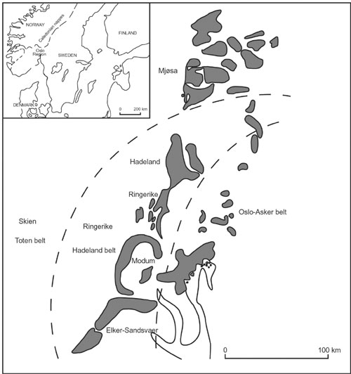
Figure 1. Distribution of Ordovician rocks and facies belts in the Oslo Region (modified after Størmer 1967).
During most of the Ordovician the central Oslo–Asker District was marked/characterised by deeper–water facies, bounded northwestwards by shallower–water facies belts (e.g., Størmer, 1967) (Figure 1). This general pattern continued from the Llanvirn into the Ashgill. The present sequence stratigraphical analysis is focussed on the deeper–water facies of the Oslo–Asker District, an approach that ensures a better possibility of detecting potential gaps relating to lowstands within the more nearshore successions of the western and northwestern districts. Moreover, the Caradoc–Ashgill successions are very well exposed in the Oslo Fjord area, where there is good biostratigraphical control. The sea level changes are identified according to shifts in lithofacies in combination with regional lithofacies distributions.
During the Caradoc three main lithofacies belts can be recognised within the Oslo basin (Figure 1). The most offshore belt comprises organic–enriched graptolite–bearing mudstones often with septarian siderite concretions, which shorewards pass into dark to lighter grey mudstones contain thin storm–generated silt– and sandstone beds. Further Shorewards the mudstones grades into nodular limestone intercalated mainly with grey silty mudstone, eventually passing into limestones, often rich in algal remains and with small organic build–ups in the most nearshore facies belt. The clastic supply, however, increased significantly in the Ashgill, reflecting a general increase in sedimentary influx into the Oslo basin from the adjacent developing Caledonide mountain chain (Bruton and Harper, 1988). For this reason clastic supply was comparatively high during lowstands with the deposition on the midshelf of light–coloured marl, silt– and mudstones with a few limestones beds, passing into a sand belt in the nearshore areas. Associated deep–water facies are not known from the Oslo area. During rising sea level and sea level highstands the clastic supply was reduced and the deep shelf was characterised by dark–coloured mudstones, occasionally graptolitic, that passed shorewards into a nodular limestone facies that farther shorewards was replaced by limestones. Clean bioclastic limestones occasionally with ooids locally characterise the most nearshore, shallow–water zones.
Oslo – Asker District
The Solvang Formation (12–23 m) consists of limestone nodules and layers interbedded with grey silty mudstone; it contrasts markedly with the mudstone–dominated units below and above, and represents a prominent lowstand during the later part of the clingani Zone. The unit is widely recognisable in the Oslo Region and forms a convenient starting point for the sequence stratigraphical analysis. The trilobites of the highly fossiliferous Solvang Formation indicate an Actonian–Onnian age (Bruton and Owen, 1979), whereas the conodonts indicate the superbus Zone (Owen et al., 199;, Bergström, 1971).
The Solvang Fomation is overlain by the Venstøp Formation (7–11 m), which consists of dark–coloured, pyritic, graptolite–bearing mudstone, indicating a major rise in sea level. The drowning commenced in the late clingani Zone, as indicated by a thin mudstone unit at Nakkholmen immediately on top of the Solvang Formation (cf., Williams and Bruton, 1983). However, the rapid and marked drowning, which accelerated into the linearis Zone, was in general associated with non–deposition in the Oslo–Asker District resulting in a gap in the succession spanning the uppermost clingani Zone and the lower part of the linearis Zone. The gap was associated with precipitation of phosphorite and clearly represents a maximum drowning surface. Drownings were not usually associated with total cessation in sedimentation in the Oslo–Asker succession (Nielsen, unpublished data), indicating that this event was unusually fast and of considerable magnitude. Deposition resumed during highstand conditions in the middle part of the linearis Zone (cf., Williams and Bruton, 1983), and the highstand persisted throughout the linearis zone, during which the Venstøp Formation was deposited. The Swedish and Estonian successions show this highstand to be composite, but the associated depositional changes are more subtle in the deep outer shelf environments of the Oslo–Asker District (Figure 2).
The composite linearis highstands were followed by a major drop in sea level, the Grimsøya Regressive Event (Figure 2); data from Västergötland and Scania (Sweden) suggest it correlates with the base of the complanatus Zone. The shallowing is expressed by the shift from the Venstøp Formation to the Grimsøya Formation (up to 46 m). The lower part of the Grimsøya Formation is characterised by numerous limestone nodule horizons, whereas the upper part consists of alternating bedded limestone/shale with some siltstone beds (interpreted as storm beds). This change signals a continued shallowing. The succeeding Skjerholmen Formation (up to 48 m) of the central Oslo Region, comprising calcareous mudstones with lime–, silt– and sandstones, is considered to indicate further shallowing; channelling and cross bedding is described from the upper half of this formation (Owen et al., 1990). The overlying Skogerholmen Formation (up to 43 m) has more abundant limestones and the silty storm layers are thinner (cf. Owen et al., 1990), which point to a moderate deepening.
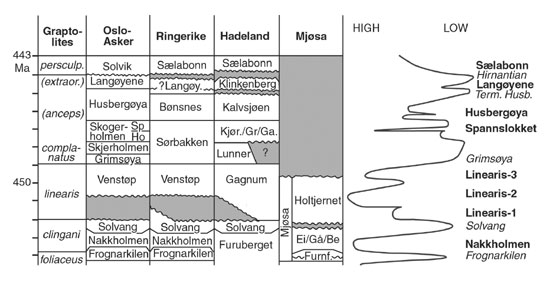
Figure 2. Upper Caradoc–Ashgill lithostratigraphy of those Oslo districts discussed in the text, plotted against the sea level curve, slightly modified from Nielsen (in press). Abbreviations: Sp = Spannslokket Mbr; Ho = Hovedøya Mbr; Kjør./Gr./Ga. = Kjørven Fm/Grinda Mbr/Gamme Fm; Ei/Gå Be = Eina/Gålås/Bergavika mbrs; Furnf. = Furnesfjorden Mbr. Named drownings in bold, lowstands in italic (modified from Nielsen, in press).
The unnamed shale unit (Isotelus Shale 4db of older literature) that forms the basal part of the Spannslokket Member of the Skogerholmen Formation undoubtedly indicates a major sea level rise (Spannslokket Drowning Event; see Figure 2) with the return to a starved, deep–water basin. This important shale unit, which is up to nine metres thick (Owen et al., 1990), is probably either Cautleyan or early Rawtheyan in age. The succeeding mudstones are interspersed by siltstones and a few limestones in the lower middle part of the Spannslokket Member, followed by an upwards–increasing abundance of limestones. This pattern reflects first a shallowing followed by a renewed deepening. The deepening heralded a new drowning event, signalled by the dark–coloured shale unit at the base of the Husbergøya Formation (up to 35 m). This Husbergøya Drowning was of longer duration than the Spannslokket highstand, an inference that is also supported by data from Swedish sections (Nielsen, unpublished data). It seems to comprise a short–lived early drowning/fairly pronounced shallowing followed by a more pervasive and renewed drowning and highstand. Rare graptolites have been reported from the Husbergøya shale (e.g., Bockelie 1982), but they are not age diagnostic.
Up through the Husbergøya Formation the sea level seems to have gradually dropped and sandy beds become more and more common. A bioturbated brownish–weathering sand unit, several metres thick, marks the top of the formation, and which is taken as a temporary lowstand (forced regression) that is widely traceable across the central Oslo Region (Brenchley and Newall, 1975). The upper part of the Husbergøya Formation correlates with the upper Rawtheyan (Owen, 1981). The shift to the Langøyene Formation (up to 60 m) is taken to signal a renewed drowning, associated with deposition of shale, laminated sandstones and thin limestones. This was a smaller–scale sea level rise, the Langøyene Drowning Event. The facies patterns of the coeval Ärina Formation of northern Estonia suggest that this early highstand was punctuated by a temporary minor shallowing (Nielsen, unpublished data), but which cannot be resolved in the Oslo–Asker sections. The higher parts of the Langøyene Formation consist almost exclusively of sand, often showing contorted bedding indicating rapid deposition. In the uppermost Ashgill oolitic limestones were deposited, succeeded by large channels incising the top of the succession (Brenchley and Newall 1980). During the mid Hirnantian the area was probably largely above sea level. The Langøyene Formation contains a Hirnantia brachiopod fauna (Cocks, 1982; Brenchley and Cocks, 1982).
In the western part of the Oslo–Asker District, the Husbergøya and lower part of the Langøyene formations are replaced by the more calcareous Langåra Formation (up to 35 m). This reflects a more shorewards position and the same succession of sea level changes can be recognised (cf., Brenchley and Newall, 1975). Around Sandvika, Bærum, Hirnantian strata are absent, and here the terminal Husbergøya shoaling seems to be associated with channelling (Brenchley and Newall, 1975).
The succession above the Langøyene Formation starts with a layer of redeposited sand followed by a thin nodular limestone interval in turn followed by graptolitic mudstones (Solvik Formation). This lithological change is taken to signal a profound and rapid sea level rise (Brenchley and Newall, 1980), referred to as the Sælabonn Drowning Event by Nielsen (in press). The Sælabonn Drowning most likely commenced in the persculptus Zone and continued into the Silurian, judging from the lithological development of the Scania–Bornholm area.
Ringerike District
The Caradoc succession of the Ringerike District is closely comparable with that of the Oslo–Asker District, and the Solvang (ca. 12 m) and Venstøp (ca. 26 m) formations record the same sea level pattern. However, in this district, located more shorewards, limestone deposition ceased later during the Linearis–1 drowning (Figure 2), and locally the upper part of the Solvang Formation, the more argillaceous Høgberg Member (3 m) of Owen (1979), is of early linearis Zone age (as indicated by the presence of the conodont Hamarodus europaensis [= N.genus and n.sp. sensu Hamar 1966], cf. Stouge and Rasmussen, 1996). The upper part of the Venstøp Formation also includes more abundant limestones horizons than farther east (cf., Owen, 1978, Williams and Bruton, 1983). According to Owen (1979) the upper part of the Solvang Formation, which contains Tretaspis of the seticornis group, is of Ashgill age, showing that the base of the Ashgill coincides with the base of the linearis Zone in the Oslo area.
The Venstøp Formation is overlain by the Sørbakken Formation, with a thickness estimated in the order of 100 m (Owen 1979). Only the lower 34 m and upper 37 m crop out, which may conceal important lithological changes and sea–level based correlation with this unit remains uncertain. Clearly the Sørbakken Formation, comprising grey, nodular and bedded limestones alternating with thin calcareous mudstones, represents shallower–water facies than the underlying dark–coloured mudstones, and it is taken to reflect the Grimsøya Regressive Event. It is currently not possible to identify further sea level changes in this unit, based on the available descriptions, except that the top of the Sørbakken Formation includes somewhat darker limestones (Hanken and Owen 1982), which are tentatively taken to reflect the renewed moderate deepening seen in the upper part of the Skogerholmen Formation of Oslo–Asker.
The overlying Bønsnes Formation, also around 100 m, is correlated with the Husbergøya Drowning. The base is marked by dark, platy limestone, followed by lighter coloured limestones. Higher levels include rubbly limestones interbedded with calcareous shales, and the highest parts comprise calcareous shales with scattered limestone nodules (Owen et al., 1990). This facies pattern is in accordance with the lowering of sea level inferred up through the Husbergøya Formation. Then follows a 40 m thick unit, tentatively assigned to the Langøyene Formation by Owen et al. (1990). It comprises a lower sandstone unit, 15 m or more, overlain by limestone with a conglomerate at the base (Hanken and Owen 1982). The sandstone is here equated with the terminal Husbergøya shoaling, followed by the Langøyene Drowning (Hirnantian). We include the limestone, which contains patches of small organic build–ups, in the Langåra Formation; it reflects a lowering of clastic supply during sea level rise. The limestone is locally cut by a karstic surface, marking the Ordovician–Silurian boundary, elsewhere it is overlain by sandstone facies (Hanken and Owen 1982), which obviously may reflect the progressive shallowing during the Hirnantian.
Hadeland
The Solvang Formation (17–70m), coincident with the Solvang Lowstand, is well developed here in the type area for the unit (Owen, 1978); apart from in SE Hadeland it contains less intercalated mudstone than in the Oslo–Asker District, corroborating a more shorewards position of the area. The succeeding Linearis Drowning–1 is marked by a shift to the Gagnum shale facies (ranked as a member of the Lunner Formation by Owen et al., 1990), which is calcareous shale with limestone nodules. We consider this unit marks a transitional lithofacies between the graptolite shale facies of the Venstøp Formation farther SE and the micritic highstand carbonates of the Holtjernet Member of the Mjøsa Formation to the north. The Gagnum shale is overlain by the limestones of the Gamme Formation in northern Hadeland and by the Lunner Formation (dark calcareous shales intercalated with some limestone) in southern Hadeland. Like for the Sørbakken Formation of Ringerike, the lack of detailed lithological information is an impediment for a sequence stratigraphical analysis. We would have anticipated a strong increase in clastic influx associated with the Grimsøya Regressive Event (in particular during the lowstand peak equivalent to the Skogerholmen Formation of Oslo–Asker District), and it is possible that a gap is represented at least in the northern Hadeland District at this level. Obviously such interpretation remains speculative, but in case the lime–rich Gamme Formation may represent the Spannslokket Drowning.
The Grinda Member (shales with some limestone beds and nodules) overlies the Gamme Formation and signals increased clastic influx during the shallowing equivalent of the middle part of the Spannslokket Member of the Oslo–Asker District. This shallowing is expressed in southern Hadeland by the shift to the Kjørven Formation (limestone and calcareous siltstone alternating with silty shales). The slight sea level rise signalled by the more lime–rich part of the upper Spannslokket Member in the Oslo–Asker District is probably correlated with the more lime–rich upper part of the Kjørven Formation. (cf., Owen, 1978; Owen et al., 1990), whereas the transition to the Kalvsjøen Formation (mainly limestones) is equated with the Husbergøya Drowning, coincident with a strong reduction in clastic supply. The marked shoaling in late Husbergøya time was associated with channelling in Hadeland within the upper part of the Kjørven Formation (cf., Braithwaite et al., 1995). The channel–fill has a karstified top, which is correlated with exposure during the peak terminal Husbergøya lowstand and which is in excellent accord with the lithological development farther south. The Langøyene Drowning was associated with deposition of the Klinkenberg Formation (bioclastic limestones, calcareous siltstones and sandstones), which upwards becomes dominated by sand, reflecting shoaling of the depositional environment. Millet seed (aeolian) sand was reported from the uppermost part of the formation by Braithwaite et al. (1995; their lithofacies 6). In our opinion the middle part of the Hirnantian is probably not represented in this district.
Mjøsa
The Mjøsa Formation (ca. 100 m) was previously correlated with the Solvang Formation by Owen et al. (1990), whereas data presented by Opalinski and Harland (1981) and Spjeldnæs (1982) strongly suggest that the Furuberg/Mjøsa transition correlates with the upper Keila to Oandu Frognarkilen Lowstand sensu Nielsen (in press). We infer that the Mjøsa area was close to emergence during peak lowstand (Sivesinhagen Beds of Opalinski and Harland, 1981) during the terminal foliaceus Zone. The succeeding units (Eina, Bergavika, Gålås members of Opalinski and Harland 1981; Units III–IV of Spjeldnæs, 1982) are taken to signal the conspicuous Nakkholmen Drowning and highstand (see Nielsen, in press), followed by the Solvang Lowstand that was even more marked than the previous Frognarkilen Lowstand. The three lithostratigraphical members indicate palaeo–depth differences within the area with the most offshore locations (Eina Member) being the most mudstone dominated during the Nakkholmen Highstand prior to the Solvang Lowstand (Figure 2). The lower main part of the Gålås Member (Opalinski and Harland, 1981, Figure 8), comprising grey micrites and peloidal limestones, mainly represent highstand carbonates associated with the Nakkholmen Drowning/highstand, whereas the succeeding coral–bearing horizon, comprising 8.5 m of poorly exposed calcareous sandstones, bioclastic limestones and mudstones, represent the Solvang Lowstand. Those lime–dominated deposits associated with the Solvang Lowstand contain reefal limestones (Eina–Bergavika members); a minor gap is inferred on top, matching the peak of the lowstand. The succeeding unit (Holtjern Member of Opalinski and Harland (1981); Units V–VI of Spjeldnæs, 1982) are taken to reflect the initial transgression (oncolites, ooids, conglomerates, siltstones at base), and highstand carbonates time–equivalent to the Venstøp Formation of the Oslo–Asker District (peloidal reticulate limestone). The more coarse–grained limestones of the upper Holtjern Member may represent the shallowing separating Linearis Drownings 2/3 sensu Nielsen (in press). The Mjøsa Formation is capped by a conspicuous karstic surface and almost the entire Ashgill seems to be missing. It is, however, uncertain whether the thin (0.5–0.7 m) sandy unit immediately on top of the formation represents the Ordovician or Silurian (Spjeldnæs, 1982). We assume that the area was flooded at least during the Spannslokket Drowning and probably also during the initial Husbergøya Drowning.
Conclusions
The new sea–level based correlation of the successions in Oslo–Asker, Ringerike, Hadeland and Mjøsa is widely applicable across the region, except for identification of the Spannslokket Drowning. This important, large–scale drowning event was of short duration; detailed data from complete exposures are required for its recognition in the thicker successions landward of the Oslo–Asker facies belt. The new framework, however, confirms that the Holorhynchus–bearing strata of western Oslo–Asker represent the Husbergøya highstand and are thus pre–Hirnantian in age (Rong and Harper, 1988, Brenchley et al., 1997). The Ringerike development of the Langøyene Formation sensu Owen et al. (1990) may represent the terminal Husbergøya shoaling (latest Rawtheyan) as well as the Langøyene Drowning (Hirnantian); the lime–rich Hirnantian strata should be assigned to the Langåra Formation. In the Hadeland District, the terminal Husbergøya and the upper Langøyene shoaling events were associated with channelling, pointing to emergence during these lowstands. The Klinkenberg Formation correlates with the Langøyene Drowning (see for example Heath and Owen, 1991; Braithwaite et al., 1995). The Mjøsa Formation spans a larger stratigraphical interval than indicated previously by Owen et al. (1990); only the uppermost part is equivalent to the Solvang and Venstøp formations of the Oslo–Asker District.
References
Baarli, B.G. 1990. Peripheral bulge of a foreland basin in the Oslo Region during the Early Silurian. Palaeogeography, Palaeoclimatology, Palaeoecology, 78: 149–161.
Bergström, S. 1971: Conodont biostratigraphy of the Middle and Upper Ordovician of Europe and Eastsern North America. Geological Society of America Memoir, 127: 217–251.
Bockelie, J.F. 1978: The Oslo Region during the Early Palaeozoic. In Ramberg, I.B. and Neumann, E.–R (Eds.): Tectonics and Geophysics of Continental Rifts: 195–202. D. Reidel, Dordrecht.
Bockelie, J.F. 1982: The Ordovician of Oslo–Asker. In Bruton, D.L. and Williams, S.H. (Eds.): Field excursion guide. IV International Symposium Ordovician System. Paleontological Contributions, University of Oslo, 279: 106–121.
Braithwaite C.J.R., Owen, A.W. and Heath, R.A. 1995. Sedimentological changes across the Ordovician–Silurian boundary in Hadeland and their implications for regional patterns of deposition in the Oslo Region. Norsk Geologisk Tidsskrift, 75: 199–218.
Brenchley, P.J. and Newall, G. 1975. The stratigraphy of the Upper Ordovician Stage 5 in the Oslo–Asker district, Norway. Norsk Geologisk Tidsskrift, 55: 243–275.
Brenchley, P.J. and Newall, G. 1980. A facies analysis of Upper Ordovician regressive sequences in the Oslo Region, Norway – A record of glacio–eustatic changes. Palaeogeography, Palaeoclimatology, Palaeoecology, 31: 1–38.
Brenchley, P.J. and Cocks, L.R.M. 1982. Ecological associations in a regressive sequence: The latest Ordovician of the Oslo–Asker district. Norway. Palaeontology 24: 783–815.
Brenchley, P.J., Marshall, J.D., Hints, L. and Nolvak, J. 1997. New isotopic data solving an old biostratigraphic problem: the age of the Ordovician brachiopod Holorhyncus giganteus. Journal of the Geological Society, London, 154: 335–342.
Bruton, D.L. and Harper, D.A.T. 1988. Arenig–Llandovery stratigraphy and faunas across the Scandinavian Caledonides. Special Publication of the Geological Society, London, 38: 247–268.
Bruton, D.L. and Owen, A.W. 1979. Late Caradoc–early Ashgill trilobite distribution in the central Oslo Region, Norway. Norsk Geologisk Tidsskrift, 59: 213–222.
Cocks, L.R.M. 1982. The commoner brachiopods of the latest Ordovician of the Oslo–Asker district, Norway. Palaeontology, 25: 755–781, pls. 78–84.
Hanken, N–M. and Owen, A.W. 1982. The Upper Ordovician (Ashgill) of Ringerike. In: Bruton, D.L. and Williams, S.H. (Eds.): Field excursion guide. IV International Symposium Ordovician System. Paleontological Contributions, University of Oslo, 279: 122–131.
Hamar, G., 1966: Preliminary report on conodonts from the Oslo–Asker and Ringerike districts. Norsk Geologisk Tidsskrift, 46, 27–83.
Nielsen, A.T. In press: Sea–level Changes – a Baltoscandian Perspective. In: Webby, B., Droser, M, Paris, F. and Percival, I. (Eds.). "The Great Ordovician Biodiversification Event", Part II. Conspectus of the Ordovician world. Columbia University Press volume.
Opalinski, P. and Harland, T.L. 1981. The Middle Ordovician of the Oslo region, Norway, 29. Stratigraphy of the Mjøsa Limestone in the Toten and Nes–Hamar areas. Norsk Geologisk Tidsskrift, 61:, 59–78.
Owen, A.W. 1978. The Ordovician and Silurian stratigraphy of central Hadeland, south Norway. Norges Geologiske Undersøkelse, 338: 1–23.
Owen, A.W. 1979. The Upper Ordovician succession of Norderhov and on Frognøya in Ringerike, Norway. Norsk Geologisk Tidsskrift, 48: 245–258.
Owen, A.W. 1981. The Ashgill trilobites of the Oslo Region, Norway. Palaeontographica Abt. A., 175: 88.
Owen, A.W., Bruton, D.L., Bockelie, J.F. and Bockelie, T.G. 1990. The Ordovician successions of the Oslo Region, Norway. Norges Geologiske Undersøkelse, Special Publication, 4: 54.
Rong Jia–yu and Harper, D.A.T. 1988. A global synthesis of the late Ordovician Hirnantian brachiopod faunas. Transactions of the Royal Society of Edinburgh: Earth Sciences, 79: 383–402.
Spjeldnæs, N. 1982. The Ordovician of the districts around Mjøsa. In: Bruton, D.L. and Williams, S.H. (Eds.): Field excursion guide. IV International Symposium Ordovician System. Paleontological Contributions, University of Oslo, 279: 148–163.
Stanistreet I.G. 1983. Contemporaneous faulting in the upper Ordovician of the Oslo–Asker district, Norway, and its significance in the development of the Oslo Basin. Sedimentary Geology, 37: 133–150.
Stouge, S. and Rasmussen J.A. 1996. Upper Ordovician conodonts from Bornholm and possible migration routes in the Palaeotethys Ocean. Bulletin of the Geological Society of Denmark, 43: 54–67.
Størmer, L. 1967. Some aspects of the Caledonian geosyncline and foreland west of the Baltic shield. Quarterly Journal of the Geological Society, London, 123: 183–214.
Williams, S.H. and Bruton, D.L. 1983. The Caradoc–Ashgill boundary in the central Oslo Region and associated graptolite faunas. Norsk Geologisk Tidsskrift, 63: 147–191.
Received: February 15, 2003
Accepted: June 15, 2003