Dynamic evolution of the Late Cambrian – Middle Ordovician rimmed shelf margin of eastern California
Oliver Lehnert1 and John D. Cooper2
1 Institut für Geologie und Mineralogie, Universität Erlangen, Erlangen, Germany. E–mail: lehnert@geol.uni-erlangen.de
2 Department of Geological Sciences, California State University, Fullerton, CA 92834–6850, USA.
Key words: Sequence stratigraphy. Platform margin. Southern Great Basin. Cambrian. Ordovician.
Introduction
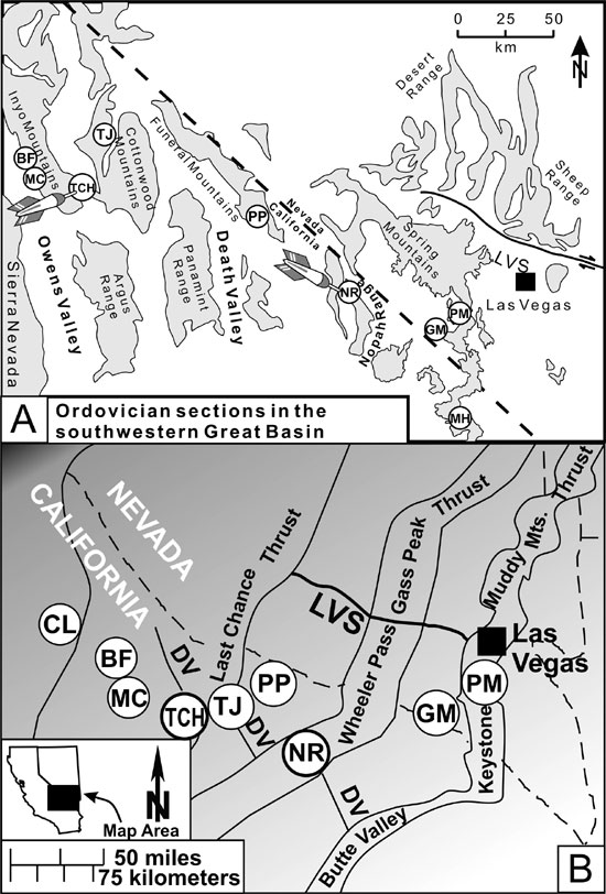
In the southern Great Basin USA, various lithologic units have been described in the lower Paleozoic platform successions of the Nopah Range, California (CA) and Spring Mountains, southern Nevada (NV), and in coeval strata of the shelf–margin to basin environments in the Inyo Mountains, CA. Previously, however, data have been collected independently from these areas and no common, correlative sequence–stratigraphic framework has been established. The Talc City Hills, CA, is a critical area for bridging both inboard and outboard stratigraphic schemes and provides a testing ground for tracing several of the sequence boundaries established by Cooper and Keller (1995, 2001) in the platform interior into the more outboard platform sections. In this short paper we focus on the evolution of this platform margin from the Late Cambrian to the Middle Ordovician.
Pre–Ordovician history
When the Middle Cambrian Bonanza King carbonate platform was exposed in the earliest Late Cambrian, the lower part of the Lead Gulch Formation (silty shales) was deposited as a low–stand wedge along the continental margin in the present–day southern Inyo Mountains, CA (Figure 1). Blocks of Bonanza King lithology were shed downslope during the onset of sea–level rise recorded at the base of the upper Lead Gulch Fm, which consists mainly of thin–bedded calciturbitites. This upper part of the Lead Gulch Fm is likely coeval with the Dunderberg Shale, deposited during the onset of transgression on the platform.
In contrast to a dominantly microbial succession in the outer platform Upper Cambrian Nopah Formation in the Cottonwood Mountains (CM, TJ, Figure 1) in western Death Valley, the more inboard platform Nopah Fm in its type section in the Nopah Range (NR), and further east, shows a characteristic pattern of alternating thick bands of light gray peritidal microbial boundstone and dark gray subtidal wackestones and grainstones (McCutcheon and Cooper, 1989). At the shelf margin setting (CM, TJ, Figure1), an impressive karst surface, associated with coarse breccia–filled pipes that cut downward several tens of m, occurs within the lower part of the upper Nopah Fm and another one occurs at its top. This paleokarst is not recorded from more inboard sections to the east and, together with the abundant microbial facies, strongly suggests evidence for a paleohigh rampart at the outer shelf rim during the Late Cambrian.
Figure 1. A. Location of sections mentioned in the text (BF – Badger Flat, CL – Convict Lake, NR – Nopah Range, MC – Mazourka Canyon, FM – Funeral Mountains, TCH – Talc City Hills, TJ – Teakettle Junction); the two "baseline achors" (NR and TCH) are marked with an arrow; LVS – Las Vegas Valley Shear, DV – Death Valley Fault Zone . B. Map based on the palinspastic reconstruction of Stewart and Poole (1974).
Bridging platform interior and platform margin domains
Decades after the early work of Hazzard (1937), who first described the classic Paleozoic miogeoclinal section of the Nopah Range (Figure 1), several sequence stratigraphic studies were conducted (e.g., Cooper and Edwards, 1991; Cooper and Keller 1995, 2001) in this and other platform sections. In the baseline NR, Cooper and Keller (1995) recognized within the previously undifferentiated Pogonip Group the classic central Nevada units: the Goodwin Limestone, the Ninemile Shale, and Antelope Valley Formation. For the first time, Cooper and Keller (2001) documented in detail paleokarst features and a swarm of at least twelve sequence boundaries from the base of the Ibexian Goodwin Formation to the top of the Mohawkian Eureka Quartzite in a transect from the outer miogeocline to the craton margin
Six of their sequence boundaries can be recognized to the west in the Cottonwood and Funeral Mountains (FM, Figure 1), and at least four surfaces have been traced into the Talc City Hills (TCH) area (Cooper and Lehnert, 2001). As important as the NR section has been as a baseline anchor for correlative bridging of outer shelf and cratonal sections (Cooper and Keller, 1995, 2001), just as important is the TCH section (Figure 1, 2) for linking successions exposed in the Inyo Mountains with those of the mid to inner platform to the east. Historically the different terminologies in both areas have complicated the correlation of their respective lithologic units.
Cambrian – Ordovician transition at the shelf margin
In this study, we use the Talc City Hills section (TCH, Figures 1 and 2) as an anchor to trace several sequence boundaries into the outboard sections of the Inyo Mountains. Here a recognizable sequence boundary separates the lower and the upper part of the Tamarack Canyon Dolomite. We can trace this surface into the Mazourka Canyon (MC) and Badger Flat (BF) sections to the north in the Inyo Mountains. Unfortunately intense sampling for conodonts in these shallow–water facies yielded very few productive residues. However, rocks in the TCH have produced conodont verification that the upper part of the Tamarack is Early Ordovician and, therefore, is coeval with the Goodwin Formation (= units 1–6 of Cooper and Keller, 2001; Figure 2) in the Nopah Range and other mid– to inner platform sections. The surface is equivalent to their sequence boundary "A" between the top of the Nopah Formation and the overlying Pogonip Group (Figure 2)
The poorly fossiliferous dolomites of the Upper Cambrian/Lower Ordovician Tamarack Canyon Formation in the TCH and southern Inyo Mtns are similar to the lithologies of the upper Cambrian Nopah Fm on the platform and, therefore, previously have been regarded to be Cambrian in age (e.g., Ross, 1965, 1966, Stevens, 1991; Stevens and Greene, 1999; Stevens and Stone, 2002; Table 1). The confident identification of Sequence Boundary "A" in the TCH demonstrates that the subtidal to intertidal "Nopah Facies", with its shallowing–upward cycles, persisted here into the Early Ordovician. Moreover, based on recognition of sequence boundary "A" in the middle of the Tamarack Canyon Dolomite in the Inyo Mountains, together with the recognition of sequence boundary "F" (Cooper and Keller, 2001) at the TCH, MC, and BF sections, we can document the shift of the edge of the rimmed shelf from the Cottonwood Mountains westward towards the Inyo Mountains district during the latest Cambrian and earliest Ordovician.
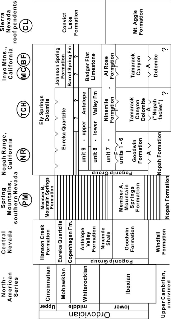
Figure 2. Correlation of lithostratigraphic units of the platform sections of the southern Great Basin with central Nevada, the Inyo Mountains, and the Sierra Nevada roof pendants.
To review, the section at BF in the southern Inyo Mtns (Figure 1) contains an upward–coarsening, shallowing succession from basinal and lower slope facies to upper slope (lower and upper Lead Gulch, respectively), and finally to shallow shelf facies (Tamarack Canyon Dolomite). This trend is similar to the pattern in the Hot Creek Range of central Nevada where a progradation of the Upper Cambrian through Lower Ordovician succession shows a basin–slope–platform margin to shelf facies transition, well documented by Cook and Taylor (1977) and Cook and Mullins (1983).
Lower/Middle Ordovician position of the shelf edge
The upper Tamarack Canyon Dolomite at BF and MC is characterized by a thick succession of very fine–grained, well–sorted subtidal grainstones, wheareas in the TCH the subtidal to intertidal facies with thrombolites and stromatolites persisted until the rapid transgression that produced the upper Ibexian (Reutterodus andinus conodont biozone) Ninemile Shale, which blanketed the different facies belts across the shelf. The limestones of the Ninemile (unit 7 of Cooper and Keller, 1995, 2001) and of its outboard equivalent, the Al Rose Fm, can be traced into basinal strata of the Convict Lake Fm within the roof pendants of the Sierra Nevada batholith (Stevens and Greene, 1999).
The Antelope Valley Formation (upper part of the Pogonip Group; Figure 2) is subdivided into two units (8 and 9 of Cooper and Keller, 1995) in eastern California and southern Nevada. Its lower unit is cliff–forming and overlies the recessive Ninemile Shale. Lithologically, the gray dolomud– and dolowackestones, oncolitic dolopack– and dolograinstones with large gastropods (Palliseria) compare well with lithologies in the Badger Flat Limestone in the TCH area and in the upper part of the Badger Flat Limestone in the southern Inyo Mountains (Figure 2). The lower (R. andinus to Histiodella sinuosa zone; Ibexian/Whiterockian transition) and upper (Histiodella holodentata to Pygodus serra zone; Whiterockian) Antelope Valley subdivisions are recognized in the TCH. A >20m–thick microbial boundstone interval in the basal Antelope Valley Fm near Teakettle Junction (TJ) to the east may indicate the shallowest Antelope Valley facies on the outer platform margin, consistent with other evidence that this area was a paleohigh (Lehnert and Cooper, 2000).
The Mohawkian Eureka Quartzite throughout the inner to middle platform domain, from the NR to theTCH, is developed as lower (transgressive), middle (transgressive to regressive), and upper (regressive) facies (Zimmerman and Cooper, 1999). However, between the TCH and the southern Inyo Mtns, the lower, transgressive facies is missing, consistent with a shelf–margin high in this area. In this light, the uppermost Badger Flat Limestone in MC might be time–equivalent to the lower facies of the Eureka Quartzite further eastward. The middle part of the Eureka is likely correlative with the Barrel Springs Formation (slope), and the upper part with the Johnson Spring Formation (shelf to slope transition) in the southern Inyo Range (Figure 2), where upper slope spillover sand bodies were derived from a thick sand build–up at the shelf margin.
Conclusions
In the southern Inyo Mountains, CA, the lower part of the Upper Cambrian Lead Gulch Fm represents low–stand deposition along the continental margin. During subsequent transgression and deposition of the Dunderberg Shale on the platform, the thin–bedded calciturbitites in the upper part of the Lead Gulch Fm were deposited. At the shelf margin (Cottonwood Mtns, Death Valley region), impressive karst surfaces occur within and at the top of the upper Nopah Fm. This, together with more microbial facies than in the inner platform sections to the east (e.g., Nopah Range), suggests a shelf margin paleohigh along the shelf rim in the early Late Cambrian.
During the Late Cambrian and Early Ordovician, the typical upper Nopah facies prograded westwards to the TCH area and beyond. The shallowest facies are shoal–water grainstones in the Tamarack Canyon Dolomite at BF in the Inyo Mountains. Here and at the TCH, the top of the Tamarack Canyon Dolomite is a karstified surface. The margin of the rimmed shelf was approximately in this outboard region and close to sea–level until the Tamarack platform was drowned and covered by the silty/shaly Al Rose Fm and its platform equivalent, the Ninemile Shale. These patterns reflect a major facies shift towards the basin with progradation of the shelf margin environments to the NW from the latest Cambrian through the early Ordovician, followed by a deepening trend and increased accommodation during the late Ibexian with deposition of the Ninemile/Al Rose.
In the Cottonwood Mountains in the Death Valley area, the basal Antelope Valley Fm is developed as a thick microbial boundstone, which is not recorded from any other out– or inboard section. This pattern is consistent with a paleohigh in this area during the Whiterockian. Here also we recognize the same karstified sequence boundaries in the lower and upper Antelope Valley Fm as in the miogeoclinal sections to the east (Nopah Range). The upper Badger Flat Limestone in the southern Inyo Mtns shows a progressive shallowing trend that likely continued during deposition of the lower part of the Eureka Quartzite further inboard on the platform. The Barrell Springs/Johnson Spring transition (Figure 2) in the southern Inyo Mtns records the spillover of quartz sand from the platform margin situated just west of the present–day TCH.
Finally, the Upper Cambrian to Middle Ordovician microbial and associated carbonate buildups along the rim of the outer shelf (Inyo Mountains, Cottonwood Mountains) do not fit with previous models of a vast westward–sloping ramp or distally steepened shelf (Cooper, 1989; Griffin, 1989). Additionally, the carbonate successions along this proposed outer shelf rim sensitively record relative sea–level changes commonly expressed by deep paleokarst, also consistent with a paleohigh at the edge of the platform.
Acknowledgements
Field work of O. Lehnert in the southern Great Basin was funded by a habilitation grant of the DFG (Le 847–1 to Le 847–4). The publication was prepared during a stay at the Charles University in Prague (Czech Republic) with a Feodor Lynen Fellowship of the Alexander von Humboldt Foundation (Bonn, Germany).
References
Cook, H. E. and Mullins, H. T. 1983. Basin margin environment. In: Scholle, P. A., Bebout, D. G. and Moore, C. H. (Eds.): Carbonate Depoisitional Environments, Mem. AAPG Memoir, 33: 540–617.
Cook, H. E. and Taylor, M. E. 1977. Comparison of continental slope and shelf environments in the Upper Cambrian and Lowest Ordovician of Nevada. In: Cook, H. E. and Enos, P., (Eds.). Deep–water carbonate environments. SEPM Special Publication, 25: 51–82.
Cooper, J. D. 1989. Does the Upper Cambrian Dunderberg Shale–Halfpint carbonate couplet in the southern Great Basin qualify as a Grand Cycle. In: Cooper, J. D. (Ed.), Cavalcade of Carbonates: Pacific Section SEPM volume and guidebook for annual meeting, Palm Springs, CA: 77 – 87.
Cooper, J. D. and Edwards, J. C., 1991, Cambro–Ordovician craton margin carbonate section, southern Great Basin: a sequence stratigraphic perspective, In: Paleozoic Paleogeography of the Western United States–II: Pacific Section SEPM, book 67: 237–252.
Cooper, J. D. and Keller, M. 1995. Ordovician craton margin –miogeoclinal transition, southern Great Basin. In: Cooper, J. D. (Ed.), Ordovician of the Great Basin: Fieldtrip Volume and Guidebook for the Seventh International Symposium on the Ordovician System, Las Vegas, Nevada: Pacific Section SEPM, book 78: 107–132.
Cooper, J. D. and Keller, M. 2001. Paleokarst in the Ordovician of the Southern Great Basin, USA, and implications for sea–level history. Sedimentology, 48: 855–873.
Cooper, J. D. and Lehnert, O. 2001. Ordovician Sequence boundaries in eastern California and southern Nevada. - Geological Society of America, Abstracts with Programs, 33 (3): A–83.
Griffin, K. M. 1989. Microbial Reefs on a Carbonate Ramp: A case study from western North America with a Global Perspective. In: Cooper, J.D. (Ed.): Cavalcade of Carbonates. Pacific Section SEPM, book 61: 101–110.
Hazzard, J. C. 1937. Paleozoic section in the Nopah and Resting Spring Mountains, Inyo County, California. Cal. Journal of Mines and Geology, 22: 273–339.
Lehnert, O. and Cooper, J. D. 2000. The Upper Ibexian–Whiterockian Antelope Valley Fm of the SW Great Basin: Sedimentologic, bio– and sequencestratigraphic aspects. Geological Society of America, Abstracts with Programs, 32 (7): 390–391.
McCutcheon, K. F. and Cooper, J. D. 1989. Environmental carbonate stratigraphy and cyclic deposition of the Smoky Member of the Nopah Formation (Upper Cambrian), Nopah Range, southern Great Basin. In: Cooper, J. D. (Ed.), Cavalcade of Carbonates; Pacific Section SEPM volume and guidebook for annual meeting, Palm Springs, CA: 87–101.
Ross, D. C. 1965. Geology of the Independence quadrangle, Inyo County, California. U.S. Geological Survey Bulletin, 1181–O: 64 pp.
Ross, D. C. 1966. Stratigraphy of some Paleozoic formations in the Independence quadrangle, Inyo County, California. U.S. Geological Survey Professional Paper, 396: 62 pp.
Stewart, J. H. and Poole, F. G. 1974. Lower Paleozoic and uppermost Precambrian Cordilleran miogeocline, Great Basin, western United States. In: Dickinson, W. R. (Ed.). Tectonics and Sedimentation. SEPM Special Publication, 22: 28–57.
Stevens, C. 1991. Paleozoic shelf–to–basin transition in Owens Valley, California. 1991 Fall Field Trip Pacific Section SEPM and Coast Geological Society. Pacific Section SEPM, 69: 37 pp.
Stevens, C. H. and Greene, D. C. 1999. Stratigraphy, depositional history, and tectonic evolution of Paleozoic continental–margin rocks in roof pendants of the eastern Sierra Nevada, California. Geological Society of America Bulletin, 111 (6): 919–933.
Stevens, C. H. and Stone, P. 2002. Correlation of Permian and Triassic deformations in the western Great Basin and eastern Sierra Nevada: Evidence from the northern Inyo Mountains near Tinemaha Reservoir, east–central California. Geological Society of America Bulletin, 114 (10): 1210–1221.
Zimmerman, M. K. and Cooper, J. D., 1999, Sequence stratigraphy of the Middle Ordovician Eureka Quartzite, southeastern Caliornia and southern Nevada, In: Kraft, P. and Fatka, O. (Eds.) Quo Vadis Ordovician?: Short Papers for the 8th International Symposium on the Ordovician System, Prague, Czech Republic, Acta Universitatis Carolinae (Geologica), 43/1–2, 147–150.
Received: February 15, 2003
Accepted: June 15, 2003