Review of Ordovician basin evolution in southern Bolivia
Sven Egenhoff1
1 Technische Universität Bergakademie Freiberg, Institut für Geologie, Bernhard–von–Cotta–Str. 2, D–09599 Freiberg, Germany. E–mail: Sven.Egenhoff@geo.tu-freiberg.de
Key words: Sedimentology. Siliciclastic shelf. Deep–marine basin. Basin evolution. Bolivia.
Introduction
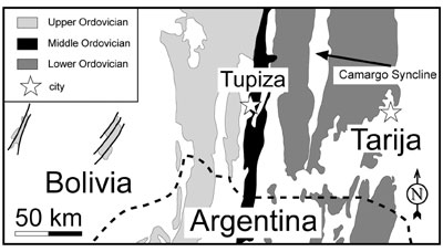
Ordovician sediments in the Eastern Cordillera and the Altiplano of Bolivia reach a cummulative thickness of more than 12 km and therewith have to be considered the most prominent Ordovician succession discovered so far. The siliciclastics have been deposited in a large, north–south trending basin running from Peru through entire western Bolivia into northwestern Argentina. This study summarizes the sedimentological approach to reconstruct the basin history for southern Bolivia (Figure 1).
Lower Ordovician shelf evolution
In the early Tremadocian, the southern Bolivian basin formed a half–graben with a steep western and a low–inclined eastern flank (Figure 2a) (Gohrbandt, 1992). Ordovician sedimentation started with a delta shedding sand, silt and mud from the Brazilian Shield towards the west (Figure 3a). Relative sea–level fluctuations caused at least one retro– and one progradation of the delta in the lower to middle Rhabdinopora zone (Egenhoff, 2000, Egenhoff et al., submitted). In the upper Rhabdinopora zone, a pronounced transgression flooded the delta, and large parts of the shelf fell below storm wave base. A submarine ramp system formed (Figure 3b), and sedimentation was dominated by laminated mudstones with turbidite sandstone intercalations. As this submarine ramp was situated in the distal prolongation of the delta, it received enormous amounts of sediment. However, thickness variations of time–equivalent strata reveal the existence of several north–south running horst blocks that subdivide the depositional site into several subbasins and still reflect its extensional character. In the early Arenig, the study area underwent a slow shallowing. A wave–dominated delta prograded more than 80 km towards the west and successively exposed the shelf (Figure 3c) (Egenhoff, 2000). Three trans– and regressions of the delta are recorded in the early to middle Arenig succession. Towards the end of the Lower Ordovician, the coastline reached a position between the nowadays Camargo Syncline and the city of Tupiza.
Middle Ordovician shelf sediments
Middle Ordovician sediments are restricted to an only ten kilometer–wide zone in the central part of the study area. The intercalations of sandstones with HCS and mudstones originated from a storm–dominated siliciclastic shoreline and reflect deposition below normal, but above storm wave base. Estimations showed that the late Darriwillian coastline position seems to have been equivalent to the late Arenig one. This indicates that the eastern shelf was subaerially exposed thoughout the Middle Ordovician. The relatively monotonous facies development of the succession at Jurcuma near Tupiza argues for less pronounced eustatic influences on deposition of the southern Bolivian Middle Ordovician (Egenhoff et al., 2002).
Figures 1. Detailed geological map of the study area in southern Bolivia showing Ordovician outcrops in the Eastern Cordillera and the Altiplano.
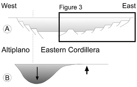
Figure 2. Profiles with the two succeeding Ordovician basin types in southern Bolivia. A. Halfgraben with a low–inclined eastern and a strong inclined western flank (Tremadoc to lower Arenig), the black margin indicates the position of the cross–section shown in Figure 3. B. Foreland basin (Lower Arenig to Ashgill).
Upper Ordovician deep–marine sediments
Upper Ordovician sediments in southern Bolivia are mostly turbidites deposited in a deep–marine foreland basin situated in the the nowaday western part of the Eastern Cordillera and the Altiplano (Figure 2b). This sedimentary trough was characterized by a steep western flank and a relatively low inclined eastern flank; the trough axis was inclined northwards. Sediment was mainly shed from the western margin. However, in the basin axis, an elongate fan system transported most of the sediment northwards. During the Caradoc, the varying sand content within the succession and characteristic facies patterns reflect changing sediment supply triggered by sea–level changes. In the Ashgill, the basin filled up with diamictites related to the Hirnantian glaciation. It remains, however, unclear if all diamictites have been deposited directly from glaciers or if they have been reworked.
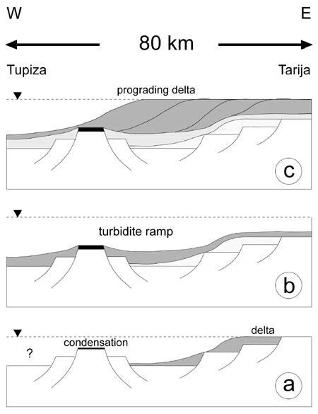
Figure 3. Model of Lower Ordovician shelf evolution in three steps. A. In the Early Tremadoc, a delta goverened sedimentation in southern Bolivia. B. Still in the Early Tremadoc, the delta was flooded and a turbidite ramp developed. C. From the Early Arenig on, a delta prograded towards the west and successively exposed the Lower Ordovician shelf.
Basin analysis
The Ordovician evolution in southern Bolivia is characterized by two basin types, an early stage rift and a foreland successor basin. The turning point in the history of this basin is reflected in the sedimentology of the Lower Ordovician shelf. The overall transgressive character of the Tremadocian and lower Arenig succession is typical for a widening rift and is also paralleled by a worldwide rising sea level (Ross and Ross, 1992). The onset of delta progradation in the early Arenig, in contrast, mirrors the beginning of compressional forces and the change into a foreland basin (Egenhoff, 2000). Subsidence analysis as well as an opposite trend of worldwide sea–level points to a tectonic reason for the regression. The shallowing and subsequent subaerial exposure of the eastern shelf during the Lower Ordovician is therefore caused by a switch from an extensional to a compressional regime.
The basin evolution in southern Bolivia is triggered by the rotational movements of a microcontinent, the Arequipa–Antofalla–Block (Forsythe et al., 1993). The basin geometries suggest that in the Tremadocian and early Arenig, this continental block moved clockwise around an Euler pole in southern Peru. When the compressional forces started in the early Arenig, the collision of this microcontinent with South America/Gondwana led to the closure of the basin in northwestern Argentina, whereas it remained open in Bolivia until the Early Silurian.
References
Egenhoff, S.O. 2000. Sedimentologie und Beckenentwicklung im Ordovizium in Südbolivien. Berliner Geowissenschaftliche Abhandlungen, A207: 1–173
Egenhoff, S.O., Maletz, J., Weber, B. and Erdtmann, B.–D. 2002. The middle Ordovician Jurcuma section: A pinpoint for basin evolution in southern Bolivia. Freiberger Forschungshefte, C497: 9–17.
Egenhoff, S., Maletz, J. and Erdtmann, B.–D. (submitted to Geological Magazine): Lower Ordovician graptolite biozonation and lithofacies of southern Bolivia: relevance for palaeogeographic interpretations.
Forsythe, R.D., Davidson, J., Mpodozis, C. and Jesinkey, C. 1993. Lower Paleozoic relative motion of the Arequipa Block and Gondwana; paleomagnetic evidence from Sierra de Almeida of northern Chile. Tectonics, 12: 219–236.
Gohrbandt, K.H.A. 1992. Paleozoic Paleogeographical and depositional developments on the central Proto–Pacific margin of Gondwana: their importance to hydrocarbon accumulation. Journal of South American Earth Sciences, 6: 267–287.
Ross, J.R.P. and Ross, C.A. 1992. Ordovician sea–level fluctuations. In: Webby, B.D. and Laurie, J.R. (Eds.), Global perspectives on Ordovician Geology, Balkema, Rotterdam, 327–335.
Received: February 15, 2003
Accepted: June 15, 2003