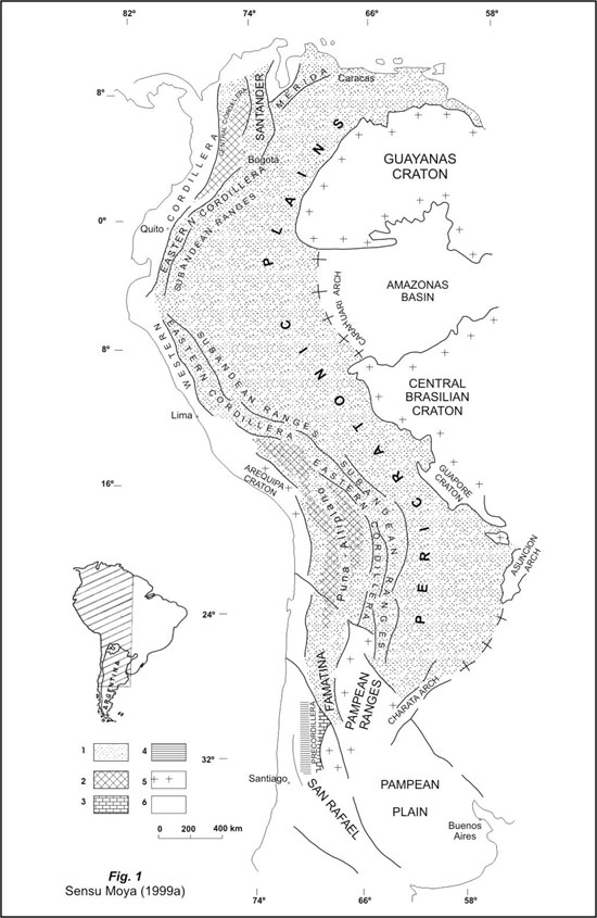
Figure 1. Distribution of Upper Cambrian–Ordovician marine deposits in South America. 1. Shelf marine–clastics deposits. 2. Deep marine–clastics deposits. 3. Shelf marine carbonatics and clastics deposits. 4. Deep marine clastics and carbonatics deposits.
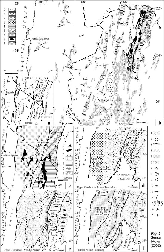
Figure 2. a. Map of Geologic Regions. b. Map of Proterozoic–Paleozoic outcrops. 1. Metamorphic basement (Proterozoic–Lower Cambrian). 2. Upper Cambrian sedimentary rocks. 3. Ordovician sedimentary rocks. 4. Silurian–Devonian sedimentary rocks (shelf deposits). 5. Devonian – Carboniferous sedimentary rocks (deep deposits). 6. Proterozoic–Middle Cambrian granites. 7. Ordovician granites. 8. Proterozoic–lower Paleozoic granites. 9. Upper Paleozoic granites. c. Paleogeologic sketch according to the age and nature of the stratigraphic nucleus. 1. Pan–American Domain. 2. Areas of uncertain age. 3. Pampean Domain. 4. Famatinian Domain. Famatinian sedimentary rocks and granites (Famatinian or younger). 5. Ordovician sinsedimentary volcanism. 6. Granites without differentiated age. 7. Old tectonic front (previous to the Upper Cambrian). d–f. Paleogeographic sketchs of the Ordovician basin. 1. Shallow areas. 2. Area occupied by the old Cambrian basin (Mesón Group). 3. Emerged to submerged areas. 4. Shallow to submerged areas. 5. Deep areas. 6. Turbidites. 7. Positive areas. 8. Sinsedimentary Volcanism. 9. Intrusives with radiometric age. 10. Storm–dominated shelf. 11. Isolated areas. 12. Lipán Swell. 13. Maximum subsidence axis. 14. Old tectonic front. 15. Erosional western border of the Ordovician basin.
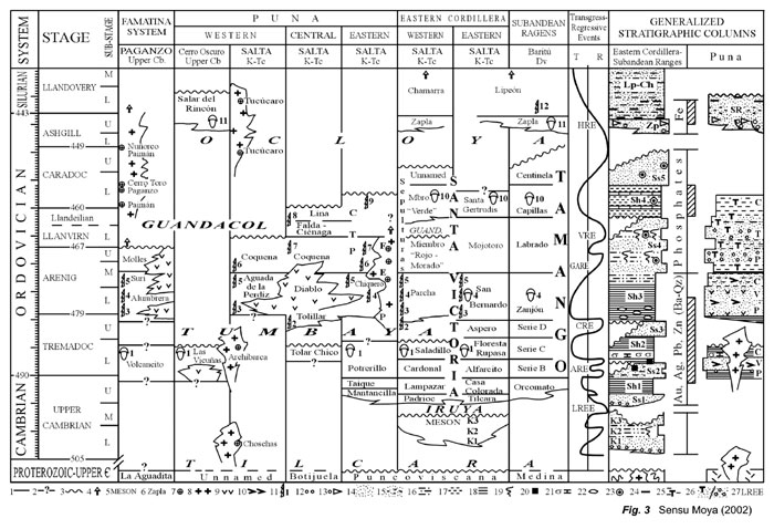
Figure 3. Correlation Chart of the Ordovician of northern Argentina. 1. Concordant
stratigraphic relationship. 2. Tectonic relationship, not exposed or unknown.
3. Unconformity. 4. Probable younger age. 5. Group. 6. Formation. 7. Radiometric
age. 8. Granites. 9. Volcanic rocks. 10. Piroclastics rocks. 11. Correlation
Time–Lines. 12. Conglomerate. 13. “Diamictite”. 14. Quartz sandstone.
15. Wacke. 16. Sandstone/Shale interbedded. 17. Silstone/Mudstone. 18. Shale.
19. Trace fossils. 20. Sulfides. 21. Calcareous coquina with Lower Tremadocian
trilobites. 22. Concretions. 23. Phosphates (nodules, crusts or lingulid coquinas).
24. Iron ore deposits (hematite, chamosite). 25. Fine–grain Turbidites.
26. Coarse turbidites. 27. Global Eustatic and/or Regresión Events.
Remarks: References 19 to 24 are the best characteristics to identify different
units.
Correlation time–lines: LT1. Coquinas with Lower Tremadocian trilobites.
LT2. A. murrayi, LT3. T. approximatus. LT4. B. vacillans, A. filiformis, B.
deflexus. LT5. D. bifidus/minutus/nitidus. LT6. A. eivionicus, P. minor, X.
svalbardensis. LT7, G. acanthus, C. antennarius, U. austrodentatus, A. cucullus.
LT8, D. cf. murchisoni, G. hincksii fimbriatus, G. cf. ciliatus. LT9, Dicellograptus
sp. LT10, “Hoekaspis schlagintweiti”. LT11, Dalmanitina subandina,
cf. Eohomalonotus, cf. Chattiaspis LT12, Talacastograptus leanzai, Normalograptus
aff. normalis, N. rectangularis.
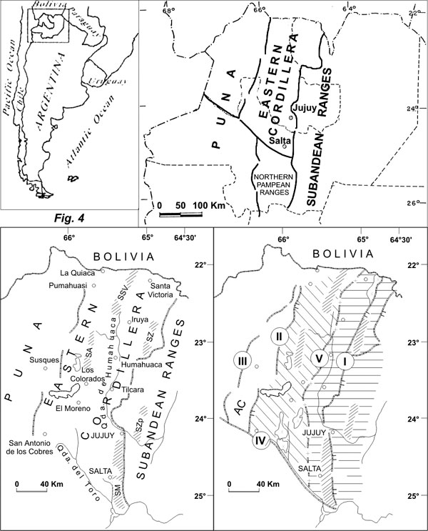
Figure 4. a. Geological Regions of Northern Argentine Andes. b. Geographic map: SSV, Santa Victoria Range. SZ, Zenta Range, SA, Aguilar Range, SM, Mojotoro Range. c. Paleogeographic map of the Chaco Shelf: Horizontal lines, Eastern Area. Inclined lines, Western Area.. I, Eastern Ocloyic Front. II, Punic Front. III, Western Ocloyic Front. IV, El Toro Lineament. V, Lipán Swell. AC, Cobres High.
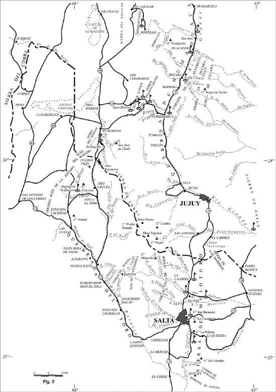
Figure 5. The Southern Part of the Argentine Eastern Cordillera. Field trip stops and Ordovician localities to be visited.
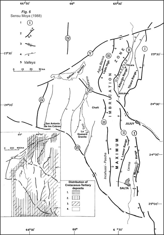
Figure 6. The Southern Part of the Argentine Eastern Cordillera. 1. Main structures. 2. Overthrust Faults: I, Eastern Ocloyic Front. II, Río Grande Front. III, Pives Front. IV, Punic Front. 3. Strike Faults: V, Salinas Grandes Lineament. VI, Volcán Lineament. VII El Toro Lineanment. 4. Other significant faults. The distribution of Cretaceous – Tertiary records. 1. Pirgua Sub–Group. 2. Balbuena and
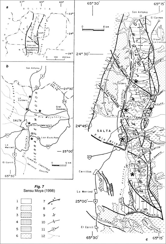
Figure 7. Mojotoro Range. a. Location map. b. Geologic map: 1, undifferentiated Quaternary. 2, Orán Group (Tertiary, Neogene). 3, Salta Group (Cretaceous–Eocene). 4, Santa Victoria Group (later Upper Cambrian –Upper Caradoc). 5, Mesón Group (Middle?–Upper Cambrian) and Santa Victoria Group. 6, undifferentiated basement (Upper Proterozoic–Lower Cambrian). 7, fault. 8, strike and dip of bedding. 9, idem overturned bedding. 10, anticline. 11, principal roads. 12, permanent rivers.
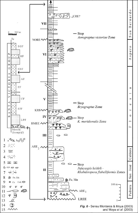
Figure 8. The Tremadocian units of the Mojotoro Range. 1a, fluvial conglomerate; 1b, fluvial–coastal marine conglomerate. 2, sandstone. 3, shale. 4, shale and sandstone. 5, calcareous mudstone. 6, gravity flows (beds and blocks). 7, mudflakes. 8, Fe–Mn nodules. 9, concretions with calcareous and iron oxide nucleous. 10, coquinite. 11, storm succession and storm beds. 12. bioturbation, trace fossils abundant. 13, cross–bedding. 14, profiles: La Quesera (1), Pascha (2), Angosto del Moreno (3), Lesser Range (4), Mojotoro Range (5) and Quebrada de Humahuaca area (6). 15, unconformity. LREE, ARE, BMEE, KRE, NORE, CRE, regressive–eustatic events. I, II, III, etc., fossiliferous intervals (trilobite and graptolite faunas, recognized by Moya et al., 2003). LPF, La Pedrera Formation. SJF, San José Formation. CF, Caldera Formation. FF, Floresta Formation. AF, Aspero Formation. SBF, San Bernardo Formation.
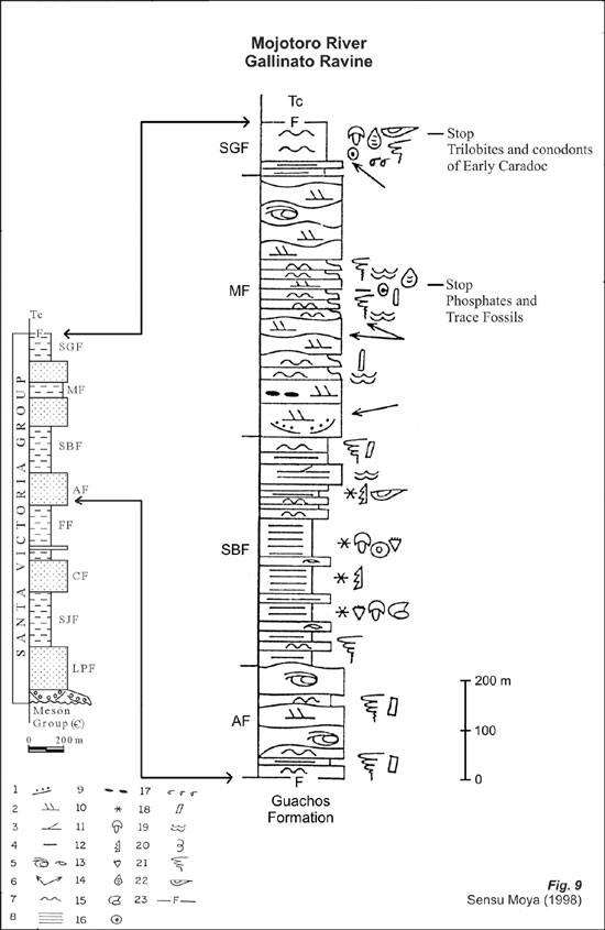
Figura 9. The Arenig to Caradoc units of the Mojotoro Range. 1, coarse, medium and fine–grained conglomerate. 2, planar and tangential high angle lamination. 3, planar low angle lamination. 4, phosphatic nodules and crusts. 5, HCS sequences. 6, paleocurrents. 7, lenticular and flaser lamination. 8, paralell lamination. 9, mudflakes. 10, fossiliferous levels. 11, trilobite. 12, graptolite. 13, articulate braquiopod. 14, inarticulate braquiopod. 15, gasteropod. 16, crinozoan. 17, coquina. 18, Skolithos sp. 19, Cruziana sp. 20, other fossil traces. 21, bioturbation. 22, bivalves. 23, fault. AF, Aspero Formation. SBF, San Bernardo Formation. MF, Mojotoro Formation. SGF, Santa Gertrudis Formation.
Figure 10. The San José Formation at Mojotoro Range, Eastern Cordillera, Salta Province.