East–West
cross–section of the Precordillera: from San Juan City to Calingasta Valley
throught the
San Juan River Valley
Silvio H. Peralta1
1National University of San Juan, CONICET, Av. I. de la Roza and Calle Meglioli, 5400 Rivadavia, San Juan, Argentina. E–mail: speralta@unsj–cuim.edu
Introduction The Precordillera Geological Province of the
La Rioja, San Juan and Mendoza Provinces (Furque & Cuerda, 1979), stretches
almost 400 km in length, and 110 km wide, at the Sierra de Villicum latitude.
It is located in western Argentina, located between the Western Sierras Pampeanas
to the east and Cordillera Frontal to the west, bounded by major tectonic features.
From north to south the Precordillera extends from La Rioja Province, through
the San Juan Province, ending on the southern margin of the Mendoza River. As
a Geological Province, the Precordillera forms part of the composite Cuyania
terrane (Ramos et al., 1984, 1986), which also includes the Sanrafelino–Pampeana
Geological Province (San Rafael and Las Mahuidas Blocks) (Criado Roque &
Ibáñez, 1979), and the Angaco Belt (Vujovich & Ramos, 1994) from the Western
Sierras Pampeanas. The Precordillera represents a high–level fold–and–thrust
belt, formed during the Andean (Miocene) orogenesis that produced crustal shortening
which affecting the whole pile of Paleozoic, Mesozoic and Cenozoic rocks, with
neotectonic features, which demonstrate that Andean deformation is still active. The structural style of the "thin skinned"
thrust–and–fold belt of the Precordillera forms a N–S mountain chain, with a
maximum elevation of 4340 m (Cerro Pircas) above sea level on the Sierra del
Tontal. The Eastern Precordillera (Ortiz & Zambrano, 1981) is characterized
by N–S striking imbricate faults with a westward vergence and thick skinned
deformation in where, in general, limestone of the uppermost part of the San
Juan Formation, form the base of the imbricates, resulting in a structural style
similar to that of the Western Sierras Pampeanas. The Central Precordillera (Baldis & Chebli,
1969) shows an eastward vergence, and the imbrications formed above a main décollement
which truncates the more incompetent sandstones and siltstones of the Devonian
and/or the Carboniferous (Von Gosen, 1992). Towards west, the dipping of the
imbricate thrust surfaces increases, with the westernmost fault planes standing
vertical or being overturned. This east to west steepening of the imbrications
is explained by a progressive migration of already stacked western imbricates
along the main décollement. This implies a ‘piggy–back’ mode in passively carrying
earlier–formed imbricated thrust sheets above a basal décollement which propagated
eastwards. Younger imbricate faults formed in front of the stack of imbricates,
while the earlier–formed imbricates continued their movement along the pre–existing
thrust faults which were steepened or overturned. Imbrications of Ordovician
to Devonian strata also occur in the Central Precordillera where Tertiary sediments
are preserved on the top of the Devonian. The Western Precordillera (Baldis et
al., 1982) shows a general eastward vergence and thick skinned deformation.
In this setting, Cambrian and Ordovician carbonate strata are absent, prevailing
Ordovician siliciclastic strata that stand vertical or overturned. In the western
flank of the Sierra del Tontal, the Late Paleozoic and Tertiary strata are gently
folded, and slices of Cambrian?–Ordovician strata are back–thrusted onto a Permian
sequence. Several authors have explained this structural styles as a result
of the interaction of the Nazca plate subducting eastwards beneath the South
America plate (Ramos et al., 1984, 1986). The ages of the individual thrusts could not
be assessed. However, the pattern of imbricate faults verging eastward, together
with the orientation of the flooring décollement, suggest that thrusting was
initiated to the west areas and then gradually propagated towards the east.
This is comparable with the situation observed in the Canadian Cordillera (Von
Gosen, 1992). As there are no Cretaceous sediments, except for a Late Cretaceous
sequence from the Huaco River section (Limarino et al., 2000), preserved
in the San Juan Precordillera, and onset of crustal shortening during Early
Tertiary and/or Cretaceous times cannot be excluded. However, basalt dykes in
the Cerro Morado anticline to the north of the Sierra de Villicum and their
radiometric dating (Cuerda et al., 1981, 1984) suggest that the Late
Cretaceous times were dominated rather by crustal extension than by crustal
shortening (Von Gosen, 1992). Few data are available to constrain the timing
of thrust movements in the region. These are mainly derived from Tertiary clastics
and volcanics (Leveratto, 1968, 1976; Contreras et al, 1990) which in
eastern regions are affected by thrust tectonics. As these clastics received
pebbles derived from the Frontal Cordillera in the west (e.g. rhyolites) it
seems reasonable to suggest that a more or less peneplained surface may have
existed before the onset of thrusting in the Precordillera (Von Gosen, 1992).
Sedimentologic and magnetostratigraphic research at several localities in the
Precordillera, combined with fission track dating of volcanic intercalations
(Tabbut et al, 1987; Beer et al., 1990; Jordan et al.,
1990), have shown that this landscape existed up to 10 Ma before present. In
eastern belt of Central Precordillera, crustal extension with the generation
of andesitic to dacite volcanics (Leveratto, 1976: K–Ar, amphibole, 47 ± 10
Ma; plagioclase, 16±2.9 Ma) pre–dates the onset of crustal shortening. Fission
track dating of pyroclastic rocks along the eastern and northeastern parts of
the Precordillera has show that the volcanic activity spanned a 10–4 Ma interval
(Johnsson et al., 1984). From a stratigraphic point of view, Precordillera
is composed mainly of a thick Early Paleozoic, Cambrian to Early Ordovician,
carbonate bank, and Early Ordovician to Devonian siliciclastic marine deposits,
all of them evolved as part of the Famatinian Geotectonic Cycle (Aceñolaza &
Toselli, 1973). The Late Paleozoic continental and marine rocks, and Early Mesozoic
rocks, belong to Gondwanan Geotectonic Cycle, which is separated from the Famatinian
Cycle by the Chánica tectonic phase, expressed as an angular unconformity in
Eastern and Western Precordillera, and an erosive unconformity in the Central
Precordillera. The Jurassic and Cretaceous rocks are recognized only in few
places of Eastern and Central Precordillera. The Neogene rocks were deposited
in continental basins, and are widely distributed in piggy–back basins between
Precordillera and Cordillera Frontal, in foreland basin within the Precordillera,
and along the boundary between Precordillera and Western Sierras Pampeanas.
These rocks have evolved during the Andean Tectonic Cycle, forming typical orogenic
thickening–coarsening upward sequences. In an E–W section of the Precordillera, Cambrian
and Ordovician carbonate platform sequences crops out in the Quebrada de Zonda,
at Sierra Chica de Zonda, in the Eastern Precordillera. In the Central Precordillera,
across the San Juan River, Ordovician limestones and Silurian to Devonian marine
siliciclastic sediments are well exposed in the Sassito, Sasso, Tambolar Pass
and Pachaco sections. Upper Ordovician siliciclastic deposits, hosting an ophiolitic
rock complex, are extensively exposed in the Western Precordillera. Along the
San Juan River section, Upper Paleozoic rocks overlying paraconformably Early
Paleozoic strata will be seen (see fig. 1, E 1). Triasic volcanic–clastic continental
strata, which are part of the oil–productive Cuyana Basin, and Carboniferous
to Lower Permian marine strata, are well exposed on the western belt of the
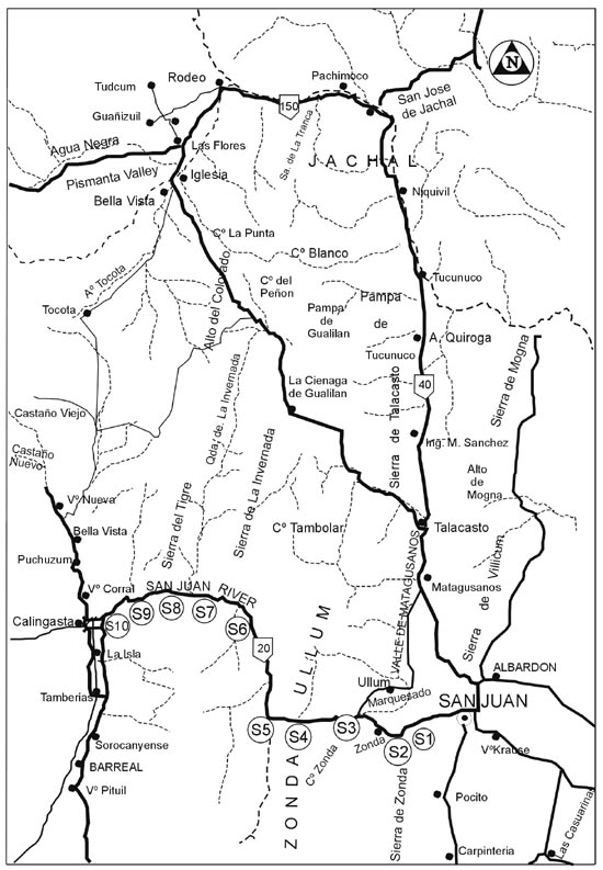
Precordillera. General features of the trip In attention not only to scientific, but also
to cultural features of this region of Argentine, stops have been scheduled
seeking to satisfy both aspects. The San Juan Province is characterized, besides
of its good wines and some times tremendous earthquakes (as in 1944 and 1977),
by a diverse native cultures which thrived mainly along the western side of
the Andean Cordillera, and to the east, on the Tulum Valley. Kaakanes and Huarpes
are, among them, the more representative native groups, and most of them were
mixed with the Spanish conquerors, but after also with Italian, Spanish and
other immigrants from different parts of the world. They live around the San
Juan River valley, surrounded by desert environment, and for a long time under
the domain of the Inca Empire. Previous to the first technical stop, the participants
will be able to see eastwards a panoramic view of the Tulum Valley, where de
San Juan City is emplaced, and the eastern slope of the Chica de Zonda range,
with a spectacular view of the neotectonic features. The Chica de Zonda range
is part of the north–south trending Villicum–Zonda–Pedernal structural arch
(Baldis et al., 1982), also called the "Zonda Swell" (Padula
et al., 1967) or "Zonda Arch" (González Bonorino, 1976). The
arch forms part of the Eastern Precordillera morphostructural setting (Ortiz
& Zambrano, 1981), with its western boundary marked by regional thrust,
the " Regional Zonda Fault", which strikes N–S dipping steeply eastwards,
and the eastern boundary is marked by a modern fault system, dipping to the
east. In this frame, imbricate faults dipping to the east often displace Cambrian
rocks. However, Silurian, Carboniferous and Tertiary siliciclastic deposits
on top of the thrust sheets are also involved. In the Quebrada de Zonda, Cambrian
rocks form the base of the imbricates, and, to the west, the dip of the imbricate
thrust surfaces increases, with the westermost fault planes standing almost
vertical. In the Villicum–Zonda–Pedernal structural arch, the regional faulting
is responsible for range elevation, as well as for the whole Precordillera,
where the main deformation and crustal shortening took place during the Late
Tertiary Field trip stops Because this will be a long day of travel, we
will not be able to make extended stops to study outcrops. Each stop has been
programmed for short time, no more than 30’, to show the Ordovician rocks in
particular thrusthed blocks, and other rocks integrating the stratigraphic succession
as well. Stop 1and 2 are in the Eastern Precordillera, stops 3 until 7, in the
Central Precordillera, stop 8 in the boundary between Central and Western Precordillera,
and stop 9 to 11, in the Western Precordillera. During the travel, while we
traverse through the Precordillera, impressive Quaternary landscapes of the
San Juan River will be seen, such as enormous alluvial fans, neotectonic activity
features, and fluvial gravel bars of braided river, among others. Stop 1: Tulum Valley Landscape and neotectonic features on the
eastern flank of the Sierra de Zonda In this stop, the participants we will be able
to have the panoramic view of the Tulum Valley, which separates Precordillera
from the Western Sierras Pampeanas, and the eastern slope of the Chica de Zonda
range, that forms part of the Eastern Precordillera morpho–structural setting,
whose western boundary is marked by a regional thrust dipping steeply eastwards,
and its eastern boundary is characterized by a modern, east depping fault system. Stop 2: Dique Soldano (Soldano dam) in the Quebrada de Zonda
(Zonda Gulch) Inside the gulch, a thick marine carbonate succession,
composed mainly of limestones and dolostones crops out (Figure 2), including
several sandstone levels and interbedded black shales, related to shallow water
environment. This Cambrian–Ordovician carbonate succession totalizes 2.500 m
in thickness, and it is composed by the La Laja Formation (Lower to Middle Cambrian),
the Zonda Formation, and the La Flecha Formation (Upper Cambrian), and typical
fossiliferous limestones of the San Juan Formation (Early Ordovician ), which
belong to a continuous sedimentary cycle. The strata are dipping to the east,
and tectonic deformation increases toward west. Along the eastern border of
the Chica de Zonda rage, the Cambrian–Ordovician carbonate sediments are covered
unconformably covered by continental red deposits Neogene of age, reach in fossil
mammals. The La Laja Formation (Borrello, 1962), 700
m thick in its type locality, is the oldest unit of the carbonate platform in
the Quebrada de Zonda section, and it is distributed along the western flank
of the Sierra de Villicum, Sierra Chica de Zonda and Cerro Pedernal. The name
is derived from the Quebrada de la Laja (Borrello, 1962), where for the first
time Cambrian faunas were described from the Precordillera (Harrington &
Leanza, 1943). Its Type Section is located in the Quebrada de Zonda, from the
western flank of the Chica de Zonda Range up to the Juan Pobre Creek (Borrello,
1962). Here, its lower boundary is unknown, because the La Laja Formation is
always cut by thrust at the base. The upper boundary is drawn at the transition
from limestones to dolomites of the Zonda Formation (Bordonaro, 1980). The best
cross–section to look the sedimentary succession of the La Laja Formation, is
displayed on the south margin of the Quebrada de Zonda, on the National Road
N° 20, which runs from San Juan City to Calingasta Valley. For the first time
Borrello (1962, 1963) discovered Cambrian trilobite fauna at the Villicum range,
to the north of the Zonda range, where he separated the fossiliferous Cambrian
rocks from the Ordovician limestones, introducing the name of "Formation
Caliza La Laja". Later, Bordonaro (1986, 1989, 2003) described in detail
the stratigraphy for the Lower and Middle Cambrian La Laja Formation (See Figure
3) The La Laja Formation is a mixed carbonate–siliciclastic
system, which in agree with Bordonaro (2003) consists of limestones, argillaceous
limestones and marlstones or siltstones, forming staked, shallowing–upward cycles,
arranged into four members (Baldis & Bordonaro, 1985): the El Estero Member,
composed by grainstones and packstones, the Soldano Member, with sandstones
and marls at the base; the Rivadavia Member, with oolitic grainstones, fossiliferous
packstones, and marls in the middle part; the Juan Pobre Member, dominantly
bioturbated mudstones and packstones at the top. Subtidal mudstones and wackestones
indicating a shallow marine platform environment, constitute the typical deposits
of the La Laja Formation, including near–shore oolite shoals (packstones and
grainstones), their distribution being related to sea level fluctuations. The
sequence reveals six major shallowing upward cycles with basal marlstones–mud–wackestones,
strongly bioturbated wacke to packstones and oolitic grainstone shoals (Bercowski
et al., 1990). On the basis of lithologic features, Bordonaro (1986,
2003) recognizes four members, which were defined from the base to upwards,
as follows: 1. El Estero Member: is formed by black cherty
limestones shales and quartzites, containing typical trilobite fauna of the
Ollenellus Zone which indicates an Early Cambrian age. The lower boundary
is unknown due to faulting, and no fossils have been found in the lowest levels,
for this reason a Early Cambrian age is estimated. 2. Soldano Member: is composed of marls and
mudstones, containing Antagmid trilobites together with chitinous–phosphatic
brachiopods indicating the trilobite fauna a lower Cambrian age. 3. Rivadavia Member: is integrated by homogeneous
set of black limestones, containing scarce trilobites and algal structures,
indicating an Early Middle Cambrian age. 4. Juan Pobre Member: consists of oolitic limestones
and black limestones to a lesser extent, bearing trilobites and brachipods in
varied abundance, which extent through most of the Middle Cambrian. Keller et al. (1998) suggest that an
important unconformity, matched by a type–1 sequence boundary, occurs between
the El Estero Member and the overlying the Soldano Member. The rocks beneath
the sequence boundary are white quartz arenites and black shales of a shallow
depositional environment. Above the unconformity, two trilobites zone seem to
be absent, indicating an erosional event which could be correlative with the
time–equivalent Hawke Bay event described from the Appalachian margin of Laurentia
(Palmer & James, 1980). The following biozones were determinate in La
Laja Formation: Bathyuriscus–Elrathina, Glossopleura, Albertela, Plagiura–Polliela
Zones in the lower Cambrian, algal structures (like stromatolites) are frequent.
Formerly, the depositional record of this unit was considered to be continuous
from the late Early Cambrian to the late Middle Cambrian. However, Bordonaro
(1999) has reported a major hiatus during the early Middle Cambrian between
the El Estero and Soldano Members. In agree with Bordonaro (1986, 1989, 2003)
and Baldis & Bordonaro (1985), the age of the La Laja Formation range from
the upper Lower Cambrian (Olenellus Zone) to upper Middle Cambrian (Marjuman
Stage, Bolaspidella Zone). Baldis & Bordonaro (1985) recognize in
the La Laja Formation, from the base to upwards, the following trilobites Biozones:
Olenellus (Lower Cambrian), Antagmus–Onchocephalus Zone (topmost
Lower Cambrian), Plagiura–Poliella Zone (base of the Middle Cambrian),
Albertella Zone, Glossopleura Zone and Bathyriscus–Elrathina
Zone (Middle Cambrian) , Bolaspidella Zone icluding trilobites of
the uppermost Middle Cambrian. The Zonda Formation (Bordonaro, 1980), is widely
distributed along the entire Eastern Precordillera and also at the Cerro La
Silla in the Jáchal area (Bordonaro, 1980), overlaying conformably onto the
La Laja Formation. Its name is derived from the Sierra Chica de Zonda, where
its type locality has been established by the mentioned author. It is composed
mainly of a succession of 300–350 m in thickness, of dolomitic limestones and
dolomites with shallow–water sedimentary structures, especially microbial lamination
and stromatolites, in which Arroqui Langer & Bordonaro (1996) have recognized
hypersaline shallowing–upward cycles. The section in the Quebrada de Zonda shows
an overwhelming majority of biolaminated deposits with only minor intercalations
of dolomitized oolites, intraformational conglomerates and (dolo) mudstones
with desiccation cracks or diagenetics evaporates. Stromatolites are rare and
belong to the LLH–type (Logan et al., 1964). In this section, small mud
mounds occur, now completely silicified, which are similar to those of the base
of the La Flecha Formation in the Guandacol area (Keller et al., 1994).
Here, the Zonda Formation is easily distinguished from the La Flecha Formation,
and such distinction is made on lithology, color of the rocks and the differing
content of stromatolites. However, sedimentologically, the lower part of the
Zonda Formation is a continuation of the uppermost sequence of the La Laja Formation,
which is indicated by the transition from oolites with herringbone cross–stratification,
in the upper part of the La Laja Formation, to inter–and supratidal dolostones
of the basal Zonda Formation. These rocks are abruptly overlain by dark subtidal
mudstones at the base of another major shallowing–upward succession (Keller
et al., 1998). The upper boundary of this cycle coincides with the boundary
between the Zonda and La Flecha Formation. Unfortunatelly, paleontological evidence for
the age of the Zonda Formation, has not been provided up to date. Despite this,
in the Zonda range the top of the underlying La Laja Formation, on the basis
of its trilobite fauna, is dated as uppermost Middle Cambrian (Bordonaro, 1980,
1986; Baldis y Bordonaro, 1985). On the other side, in the Quebrada de La Flecha
section, to the south of the Quebrada de Zonda, a significant trilobite fauna
provided by strata of the La Flecha Formation, indicates a Franconian age. On
the basis of the biostratigraphic contents of the La Laja and La Flecha Formations,
the age of the Zonda Formation there seems to comprise the span between the
Middle/Upper Cambrian boundary and the lower part of the Franconian, in this
way, a Dresbachian/lower Franconian age of the Zonda Formation is most probable
(Keller et al., 1994; 1998). The La Flecha Formation (Baldis et al.,
1981) is 400 m in thickness, and overlain conformably the Zonda Formation. Its
name is derived from the type locality in the Quebrada de La Flecha, at the
southern part of the Sierra Chica de Zonda, where the formation is widely distributed
and its Type Section is located (Baldis et al., 1981). The lower boundary
is marked by the first beds with abundant true stromatolites (LLH and SH types)
and thrombolites, and the upper boundary is drawn, where the content of stromatolites
rapidely decreases and limestones predominate over dolomitic lithologies. In
other sections, the lower boundary is marked by the change from predominantly
white dolomites towards yellow or brown dolomites and calcareous dolomite (Keller
et al., 1994). In the type locality a varied trilobite fauna occurs indicating
a Franconian to at least Late Trepeleauan age (Saukia Zone), whereas
a Dresbachian age (Crepicephalus Zone) is recognized to the northern
Precordillera (Vaccari, 1994). The facies and sedimentology of the La Flecha
Formation were considered by Keller et al. (1989) in its type section.
In the Quebrada de Zonda (Zonda gulch) La Flecha Formation exhibits a conspicuous
lithostratigraphic sequence composed of two similar shallowing–upward sequences,
but there is no well–defined boundary between them. In the lower cycle the abundance
of calcrete horizons increases towards the top, but calcretes are absent above
the presumed cycle boundary. A reversed pattern is visible in the distribution
of thrombolites, which became less abundant towards the top of the cycle and
are absent in the uppermost interval, but regain importance at the base of the
next cycle. Both sequence boundaries within the La Flecha Formation either show
signs of sub–aerial erosion, coarse detrital quartz, abundant evaporites, or
concentrations of calcrete horizons just beneath the main surface. For this
reason, each one of these sequence boundaries has to be regarded as a type–1
sequence boundary (Keller, 1997; Keller et al., 1998). It is presumed
that these sequences plus the La Flecha Formation sequences were deposited during
approximately 10 Ma, which qualifies them as third–order sequences (Keller,
et al., 1989, 1998). The age of the La Flecha Formation, early was
suggested by Baldis et al. (1981) as Upper Cambrian–Lower Ordovician?,
on the basis of the stratigraphic inference. Later, Keller et al. (1994)
suggest that a (late?) Franconian to at least late Trempealeauan age (Saukia
Zone) is probable for the La Flecha Formation, according to fossil record from
the base of the overlying La Silla Formation at cerro La Silla section, which
belongs to the uppermost Cambrian or earliest Tremdoc. Otherwise, trilobite
faunas were found in the Quebrada de La Flecha (type section) and in the section
of the Guandacol area. In the former, Plethopeltis cf. saratogensis,
indicating a late Franconian age (Ludvigsen & Westrop, 1983) is recorded
near the base of the La Flecha Formation (Keller et al., 1994). In the
middle part of this unit, Stenopilus convergens (Raymond) appears, which
indicate a late Trempealeau age (Saukia Zone) (Longacre, 1970; Ludvigsen
et al., 1989). On the other side, in the La Angostura section, in Guandacol
area, several trilobite faunas has been recorded, there, the earliest is composed
of Madarocephalus laetus Rasetti, Komaspidella laevis Rasetti
and Crepicephalus cf. C. scilisis Resser, together other new species,
which indicate the Crepicephalus zone (Dresbachian). In this section,
in the upper part of the La Flecha Formation, Drytremacephalus strictus
Rasetti indicates the Aphelaspis zone (Westrop, 1992). The La Silla Formation (Keller et al.,
1994) constitutes the youngest Cambrian litho–stratigraphic unit for the Villicum–Zonda–Pedernal
structural arch, continuing toward north, in the La Silla and Guandacol areas.
This formation was defined at the Cerro La Silla section, 350 m in thickness,
where paleontological material composed of trilobites and conodonts faunas indicate
a Late Cambrian (uppermost Trempealeau) to uppermost Tremadoc (deltifer
zone) age. A similar thickness to this unit is given at the Quebrada de Zonda
section (Keller et al., 1994), where the calcareous deposits of the La
Silla Formation display on the eastern side of the Zonda range, increasing thickness
southwards, to the Quebrada de Las Lajas and Quebrada de La Flecha, respectively.
This formation is predominantly a calcareous unit with dolomites displaying
oftenly in biolaminated horizons. The succession is composed of an alternation
of peloidal grainstones, intraclast grainstones and mudstones, with abundant
bioturbation. Oolites deposits may show cross–bedding, wackestone deposits are
significant, because yield diagnostic conodont faunas, showing typical association
of nautioids and gastropods. No cycles or sedimentary rhythms could be demostrated
to date (Keller et al., 1994). At Cerro Viejo de San Roque, to the southern
of the Jáchal City, high–spired, conispiral gastropods, occurring in the upper
part of the La Silla Formation, suggest a Early Ordovician age. However, no
indicative macrofossil has been reported from the La Silla Formation in the
Quebrada de Zonda range. On the other hand, at the type section of this unit,
in the Cerro La Silla, trilobites of the Saukia serotina to the Missiquoia
depressa subzone of Norh America, had been recorded (Keller et al.,
1994), likewise, condonts of the Clavohamulus hintzei subzone of the
Cordylodus intermedius Zone. In the upper part of the formation, the
conodont fauna belongs to Paltodus deltifer Zone. It is noteworthy that
the San Juan Formation not outcrops in the Quebrada de Zonda, although toward
the south, in the Quebrada de Las Lajas, a part of this unit has been recognized
by Beresi & Bordonaro (1984). There, the Ordovician limestones are overly
in angular unconformity by Carboniferous continental deposits. Stop 3: Embalse Punta Negra –Cerro Blanco (Punta Negra Dam–Blanco
Hill) This stop is located in the eastern border of
the Central Precordillera, where the thrust sheets show eastwards vergence.
Towards north, on the northern margin of San Juan River, small outcrops of the
San Juan Formation are sparsely distributed between the Neogene volcanic and
volcanic clastic exposures. Silurian and Devonian sicliciclastic deposits are
extensively exposed. The first one are referred to the Tambolar Formation (Heim,
1952), whose type locality is located to the west, in the Tambolar Pass, on
the San Juan River transverse. It shows Graptolite are not recorded at present
in the Silurian deposits of the San Juan River area. The base of this unit remains
unknown due to tectonic and Neogene intrusion events. The Talacasto Formation
conformably overlies the Tambolar Formation, and its top is affected by faulting.
It shows shallowing upward arrangement, and it is composed by bioturbated greenish
gray phosphate–rich mudstones, succeeded by siltstones and fine–grained sandstones,
with HCS structures. Fossils are sparsely distributed in the whole formation,
and faunal content is dominated by trilobites, brachiopods, gastropods, bivalves,
corals and crinoids, among others. Brachiopod fauna is characterized mainly
by the occurrence of Australocoelia, Schellwienella, Austrolospirifer, Scaphiocoelia
and Pleurothyrella genera, among others. In the Punta Negra Dam, crops out the type section
of the Punta Negra Formation (Bracaccini, 1950; Padula et al., 1967),
which according to recent biostratigraphic data (Peralta et al., 1995,
Herrera and Bustos, 2001) span Lower to Middle? Devonian. This unit is composed
of an over more 1000 m thick siliciclastic marine sequence dominated by mudstones,
sandstones and shales, which bear abundant plant debris and trace fossils of
the Cruziana Ichnofacies related to shallow–water environment. The paleocurrent
data shows unimodal and bimodal low–scattered designs with a mean direction
of approximately 270°, resulting in patterns transverse to the basin axis (González
Bonorino, 1975; Bustos, 1996). This areal uniformity of the data for more than
100 km, suggest that turbidity currents have multiple point sources aligned
longitudinally transporting sediments from the east to west. The lateral facies
arrangement and architectural elements show multiple interdigitations between
lobes and distributary channels. Scarce synsedimentary deformation together
with the width and character of the channels, allow to infer a depositional
substrate of very low gradient (less than 1°) (ramp–like) (Bustos, 1996). The abundance of plant debris and thorough bioturbation
along with the presence of wave reworking, might indicate sedimentary process
operating in relative shallow waters, with depth of about 200 m at the most.
Taking into account the thickening–upward sequence, as well the sandstones as
the predominant lithology and showing the sedimentary structures and plant remains
evidences of relatively shallow marine setting near to the shorline, a deltaic
model progradding over a ramp margin has been suggested by Bustos (1996; Bustos
& Astini, 1996) against the submarine fan model formerly proposed by González
Bonorino (1975) and González Bonorino & Middleton (1976). The Punta Negra
Formation is unconformably overlain by Miocene continental red deposits, intruded
by a Miocene to Pliocene subvolcanic dacite–andesitie bodies, bearing some of
them xenoliths of sedimentary and metamorphic rocks. This metamorphic xenoliths
are though coming from the basement of the Precordillera, and in agree with
isotopic dating a Grenvillian age is point out (Kay et al., 1996). Towards
east, at the northern margin of San Juan river, Devonian rocks of the Punta
Negra Formation are unconformably covered by continental and marine Carboniferous
strata bounded by a basal erosional surface. They are composed of a light reddish
arkosic sandstones and siltstones, which include some conglomerate levels. Stop 4: Quebrada Río Sassito (Sassito River Creek) The sedimentary succession exposed here is composed
of fossiliferous limestones of the San Juan Formation (Lower–Middle Ordovician),
the lower part of which has been eliminated by overthrus. Limestones are conformably
overlain by calcareous and mixed, siliciclastic–calcareous deposits of the Sassito
Formation (Astini & Cañas, 1995), of Upper Ordovician age (Lehnert, 1995),
that shows at the upper part higher content of terrigenous material. This unit
is in turn disconformably overlain by siliciclastic marine deposits of the Tambolar
Formation, Silurian in age, which are interpreted as shallow water environment,
bounded by an erosive surface at the base, and by paraconformity on top. This
unit contains abundant trace fossils of the Cruziana Ichnofacies, and
HCS structures evidencing storm–influenced environment. They are conformably
overlain (paraconformity) by fossiliferous and bioturbated mudstones of the
Talacasto Formation (Lower Devonian) showing a coarsening–thickening upward
sequence arrangement. This unit, in turn, is conformably covered by a siliciclastic
heterolitic sequence composed of dark greenish wackes and shales of the Punta
Negra Formation, Lower to Middle? Devonian in age, that bears plant remains
and trace fossils of the Cruziana Ichnofacies. The younger deposits that
crops out in this area, are represented by Carboniferous continental sediments
(fluvial, glacial and deltaic deposits, with coal– bearing strata), that includes
several fossiliferous marine levels, bounded by erosive surface at the base.
Stratigraphic arrangement in the Sassito Creek is as follow: The San Juan Formation is the older unit recognized
in this area, and it is bounded by the Sassito thrust at the base, and at the
top is overlaid by the basal conglomerate of the Sassito Formation. This unit
crops out sparsely on the western margin of the Sassito Creek, as isolated blocks
distributed southward and towards the north of the San Juan River. It is composed
mainly of fossiliferous limestones which exhibit in the upper part dissolution
phenomena. On the basis of its paleontological content this unit is assigned
to Arenig. In accordance with Astini & Cañas (1995),
the carbonate succession of the Sassito Formation, 24.5 m in thickness, is Upper
Ordovician (Caradoc–Lower Ashgill) carbonate succession. It is a thinly stratified
thinckening–upward and strongly episodic unit outcropping in the Sassito thrust
in the Central Precordillera, on the southern margin of the San Juan River.
This unit represents the youngest carbonate succession described in the Lower
Paleozoic of the Precordillera. Formerly, it has been considered as part of
the San Juan Formation but recent surveys allowed to determine the existence
of an important erosive and nondepositional gap between them, as show by a thin
horizon of chert and limestone conglomerates and coarse calclithites which cover
the San Juan Formation. The conglomerates are succeeded by 5.5 m of condensed
black shaly mudstones. Several lithofacies are identified within the Sassito
Formation: a) black calcilutites (shaly mudstones), b) coarse fossiliferous
calcarenites (calclithites), seldom graded, c) thin–bedded calcarenite/calcisiltite
rhythmites with variable degree of bioturbation, and d) laminated (with frequent
low angle corss–laminations) fine–grained calcarenites (Astini & Cañas,
1995). The upper part of the Sassito Formation represents
the episodic sedimentation of a storm–dominated carbonate shallowing–upward
succession deposited on a shallow carbonate ramp, mostly between the storm wave
base and the fair weather wave base. A gradual stratofabric change from tabular
to lenticular allow to interpret a progradational arrangement from mid–ramp
to lower shoreface. In the mid–ramp a better preservation of trace fossils allows
to differentiate pre and post event burrowing. In the shoreface some isolated
gutter casts were described, whereas hummocky cross–stratification and swaley
cross–stratification dominate the lenticular pattern. The aspect ratios as well
as the sizes of hummocks and swales are lower than average, and in plan view
out of phase (discordant) pyramidal oscillatory megaripples are present. Because
of its erosive boundaries and shallowing–upward arrangement, the Sassito Formation
is interpreted to involve part of a transgressive system tract and a highstand
succession, in which the transgressive surface is coincident with the basal
sequence boundary. An earlier (Early–Middle Ordovician) relative sea–level drop
is evidenced by a chert and fossiliferous limestone conglomerate and red dolomitized
breccia, which caps the San Juan Formation locally. The onlapping black calcilutites
can be regarded as a highstand condensed deposit (Astini & Cañas, 1995). The peculiarity of the Sassito River section
is that this is the only locality where authochthonous Upper Ordovician limestones
are exposed in the Precordillera. The top of the San Juan Formation is overlain
by a thin chert pebble conglomerate (0.45 m thick) with Cruziana traces
and fragments of brachipods of, presumably Llanvirnian age (Lehnert, 1995a).
This indicates a first erosion event on the top of the San Juan platform. The
conglomeratic layer is covered by dark shales, bioturbated greenish siltstones
and calcareous sandstones with chert clasts, bryozoans and solitary corals.
The first grainstone horizons yielded Ansella nevadensis (Ethington and
Schuhmacher), Panderodus aff. bergstroemi Sweet, Dapsilodus
mutatus (Branson and Mehl), Plectodina sp., recrystallized Belodina
sp. and reworked Histiodella fragments possibly of H. holodentata
and very thin and fragile (?juvenile) elements of aff. Plegagnathus nelsoni
Ethington and Frunish. From a horizon 2.85 m below the top of this unit elements
of Apheolognathus politus (Hinde), aff. P. nelsoni, A. nevadensisk
and reworked material (H. holodentata and Histiodella? sp.)
were obtained. The correlation of the distinct conodont associations mainly
is based on the comparison with zonations and composite range charts of Sweet
(e.g., 1984) and was discussed in detail by Lehnert (1995b). The condensed
succession might bear a hiatus as reflected by reworked faunal elements. The
evolution of the platform began presumably during Late Llanvirnian times and
at least persisted to the Middle Caradoc, perhaps even into the Ashgill based
on the occurrence of A. politus (Lehnert, 1995a). The Sassito Formation
probably correlates with part of the Empozada Formation, from southern Precordillera,
and the Trapiche Formation, from northern Precordillera, where late forms of
the Amorphognathus conodont genus have been recorded (Heredia et al.,
1990; Albanesi et al., 1995). The Tambolar Formation (Heim, 1952), 150 m thick,
is Silurian in age, and the oldest siliciclastic unit exposed in this area,
being characterized by a thickening–upward succession. It unconformably overlies
(erosional surface) the Sassito Formation, and at the top it underlies paraconformably
(paraconcordance) the Lower Devonian fossiliferous mudstones of the Talacasto
Formation. The succession starts with a basal cherty pebbly tabular conglomerate,
30 cm thick, which is succeeded by a thin, over 80 cm, argillite succession,
continuing upward phosphate rich mudstones, 50 m thick, thin bedded wackestone
and mudstones, 50 m thick, and the upper part it is dominated by thin to medium
bedded wackestone and scarce intercalations of mudstones. The whole succession
contains abundant trace fossils of the Cruziana Ichnofacies (Aceñolaza
& Peralta, 1991) evidencing a shallowing upward trend. The Talacasto Formation, 270 m thick, is Lower
Devonian in age, exhibiting also thickening–upward siliciclastic arrangement.
It paraconformably overlies the Tambolar Formation, and at the top underlies
the basal muddy succession of the Punta Negra Formation. The Talacasto Formation
is composed mainly of bioturbated phosphate rich mudstones at the lower part,
bearing shelly fauna (brachipods, bryozoans, corals, bivalves, ostracods, and
trilobites) and trace fossils of the Cruziana Ichnofacies (Baldis &
Peralta, 1999). From a sedimentological point of view, this unit has been interpreted
by Astini (1991) as a muddy shelf environment. Shelly fauna appears distributed
in the whole sequence and it is characterized by the occurrence of brachiopod
remains such as Australocoelia tourtelotti, Schellwienella inca, Australospirifer
antarcticus, and A. kayserianus, among others (Baldis, 1975; Herrera,
1990). The Punta Negra Formation, over 1000 m thick
measured in this locality, between the Sassito and Sasso creeks, by Peralta
& Ruzycki (1990), is Lower–Middle? Devonian in age (Peralta et al.,1995;
Herrera & Bustos, 2001). As the underlying Talacasto Formation, this unit
exhibits a thickening–upward sequence, and it is composed mainly in the lower
part of reddish and greenish shales and bioturbated mudstones, which are succeeded
by greenish siltstones bearing trace fossils of the Cruziana Ichnofacies
(Baldis & Peralta, 1999). Towards the upper part the succession is dominated
by interbedded graywackes, shales and siltstones including in places, plant
remains. This unit underlies unconformably (erosional surface) the continental
and marine–continental Carboniferous deposits. The mentioned unconformity is
related to the Chánica tectonic phase which marks the upper boundary of the
Famatinian Geotectonic Cycle in Argentina. Stop 5: Río Sasso (Sasso River) This stop is no more than 5 km westward of the
Sassito creek, for this reason, both sections show stratigraphic similarities
among them. In this place the Los Caracoles dam is being built, as part of the
Los Caracoles–Tambolar hidroelectric complex. Here, the succession starts with
the limestones of the San Juan Formation, which is overlain unconformably by
basal sandstones (wackes) of the Tambolar Formation (Silurian). This unit is
made up by yellowish and greenish mudstones, siltstones and waquestones, which
show a thickening–coarsening upward sequence, containing abundant trace fossils
of the Cruziana Ichnofacies. It is noteworthy the lack of the cherty
basal conglomerate present in the Sassito creek section. At the top, the Tambolar
Formation is conformably overlain by fossiliferous basal mudstones of the Talacasto
Formation (Lower Devonian, Lochkovian–Pragian until Emsian), which in turn is
also conformably overlain by fossiliferous mudstones and siltstones passing
upward to wackes of the Punta Negra Formation (Lower Devonian, Emsian, until
Midd? Devonian). This unit also is characterized by thickening–coarsening upward
sequence, bearing abundant trace fossils of the Cruziana Ichnofacies
(Peralta & Ruzycki, 1990; Baldis & Peralta, 1999), and HCS (hummocky
cross stratification) structures, indicating shallow water environment. At the
top, this unit is unconformably (erosional unconformity) covered by continental
and mixed deposits of Upper Carboniferous age, and this unconformity is related
to Chánica tectonic phase, which separates both the Famatinian and Gondwanan
Geotectonic Cycles, and show widespread distribution overall Argentina and neighboring
countries. The main difference between the Sasso and the Sassito sections is
the absence in the former of the limestnes of the Sassito Formation, owing to
subsequent erosive events (Base of the Tambolar Formation) that actuated in
the Sasso Creek section. Stop 6: Portezuelo del Tambolar (Tambolar Pass) This stop is placed in the highest point on
the road from the San Juan city to Calingasta Valley, in the southern margin
of the San Juan River. The sedimentary succession is similar to that of the
Sasso Creek. The oldest unit exposed in this section is the San Juan Formation,
composed mainly of fossiliferous limestones including in the upper part several
bentonite levels. This Ordovician limestones form the base of the thrust verging
to the east. For this reason, the base of the San Juan Formation remains unknown,
and the top is unconformably overlain by siliciclastic marine deposits of the
Tambolar Formation. The Tambolar Formation (Heim, 1952), 74 m thick
(Peralta & Carter, 1990), is Silurian in age. It unconformably overlies
the limestones of the San Juan Formation, and in turn is unconformably (paraconcordance)
overlain by the Lower Devonian Talacasto Formation. Shallowing–upward succession
of the Tambolar Formation can be observed in detail in this section, which is
the type locality of this unit. According to Peralta & Carter (1990), thin,
normally graded sandstones interbedded with bioturbated mudstones characterize
this unit. In places, the laterally extensive sandstones, which are in sharp
contact with the mudstones, are capped by hummocky cross–stratification (HCS).
In addition, the bases of some sandstones contain accumulations of fossils such
as articulated brachipods, and in the mudstones, trace fossils of the Cruziana
Ichnofacies (Peralta & León, 1997). The association of the HCS with
the graded sandstones, and the fossils indicate a platform environment, below
the fair–weather wave base. The sands were probably transported by turbidity
currents generated by liquefaction of shoreface deposits during storms. Subsequent
reworking of the graded sands below the fair–weather wave base by wave and currents
produced the HCS. The overall coarsening upward nature of the formation and
the change from a high diversified to a low diversified ichnoguild, evolved
within of the Cruziana Ichnofacies, implies a seaward migration of the
platform deposits (Peralta & Carter, 1990; Aceñolaza & Peralta, 1991). It is noteworthy that the stratigraphic correlation
of the basal cherty pebbly conglomerate of the Tambolar and La Chilca formation
is based both in lithological and biostratigraphic data. A Late Ashgillian (Hirnantian)
age has been recognized for that basal level, towards the north, in the Los
Baños de Talacasto section (Cuerda et al., 1988), which underlain a thin
mudstone level bearing graptolites of the persculptus Zone, and associated
palynomorphs (acritarchs and chitinozoans) (Melendi &Volkheimer, 1982).
On the other side, the basal conglomerate level of the Tambolar Formation is
overlain by a thin bioturbated mudstone level bearing a palynologic assemblage
dominated by forms of acritarchs and prascinoficeas indicating a Late Llandovery
to Early Wenlock age (Peralta et al., 1997). The Silurian age of the
Tambolar Formation is well constrained on the basis of its brachipod fauna composed
by Australina jachalensis, Salopina cf. missendenensis, Isorthis
sp., and Clarkeia tambolarensis, among others (Castellaro, 1959; Benedetto
et al., 1996; Benedetto and Franciosi, 1998). The Talacasto Formation, almost 180 m thick,
is Lower Devonian in age. It paraconformably overlies the Tambolar Formation
and, in turn is paraconformably overlain by the Punta Negra Formation. The lower
part of the unit is mainly composed by bioturbated fossiliferous greenish and
yellowish phosphate rich mudstones, bearing abundant coral remains formerly
assigned to "Favosites" genera (Baldis, 1975). This deposits
are succeeded upward by laminated siltstones with abundant articulated and inarticulated
brachipods, bivalves, crinoids, bryozoans, and in the upper part a conspicuous
sandstone level, no more than 1 m thick, exhibiting water escape structures,
is interbedded in the siltstones. The Lower Devonian fauna on this unit is mainly
characterized by the occurrence of Australocoelia tourtelotti, Schellewienella
inca, Australospirifer antarcticus, A. kayserianus, among others. The Punta Negra Formation crops out towards
west, from this area up to the Pachaco locality. It is composed of siliciclastic
deposits that are widely distributed forming most of the exposures, in several
imbricates along the San Juan River. This unit overlies conformably the uppermost
sandstones of the Talacasto Formation, and at the top is disconformably (erosional
surface) overlain by Upper Carboniferous continental and mixed (marine and continental)
deposits, which in part include fossiliferous marine levels. However, in some
places due to tectonic effect, the Devonian succession is repeated by thrusting.
The erosional surface between both Carboniferous and Devonian deposits is though
evolved as a result of the Chánica tectonic phase, which developed an angular
unconformity whether in the Eastern as well as in the Western Precordillera.
It is noteworthy that in this place occurs the last outcrop of the Talacasto
Formation which lacks in the Early Paleozoic stratigraphic framework in the
western section of the Precordillera. Stop 7: Pachaco Checking Point (Control de Pachaco) In this locality, the Lower Paleozoic succession
was formerly considered by Beresi (1980) who mentioned the finding of Silurian
ferriferous levels. Here, the thicker carbonate sequence of the Lower–Middle
Ordovician San Juan Formation forms the base of two east–directed imbricate
sheets, indicating a deeper position of the main décollement. They are doubled
by an imbricate fault, and the western carbonates are unconformably overlain
by Silurian to Devonian deposits (Von Gosen, 1992). In this scenario, the more
conspicuous thrust is represented by the limestone block named as Cerro Blanco
de Pachaco, which is bounded on the east side by thrust fault verging eastwards. The stratigraphic succession initiates with
fossiliferous limestones of the San Juan Formation, composed by yellowish and
grayish dolomite and calcite laminated thin beds. At the upper part this unit
shows a thicker carbonate sequence dominated by dolomite and calcite banks,
with thin yellowish K–bentonite level interbedded, and at the top is formed
by argillaceous limestones interbedded with thin calcareous shales. The base
of this carbonate succession remains unknown because its lower part is affected
by the overthrust, and at the top is unconformably underlain by the Silurian
basal conglomerate horizon. The age of the limestone is Arenig to Lower Llanvirn
according to the conodont record by Serpagli (1974) and Lehnert (1995). Silurian deposits are represented by greenish
and reddish muddy shelf facies named as the "Pachaco Facies of the Tambolar
Formation" (Peralta & León, 1993), made up of greenish (lower Member)
and reddish (upper Member) bioturbated mudstones and siltstones, which in the
upper part includes thin fossiliferous storm–sandstone–beds. They are conformably
overlain by siliciclastic marine deposits of the Punta Negra Formation (Lower–Middle?
Devonian). It is noteworthy that the Talacasto Formation is not exposed in this
area, and the hiatus between the Tambolar and the Punta Negra formations is
longer in this section. From a paleobiological point of view, Silurian deposits
informally called "Pachaco Facies", are characterized by the occurrence
of trace fossils of Zoophycos (Peralta & León, 1993), and the Cruziana
Ichnofacies (Peralta et al., 1997), and brachipods indicating a Wenlock
age (Benedetto & Franciosi, 1998). However, based on palynological data
(Pöthe de Baldis, personal communication) and regional correlations, a Ludlowian
age is also suggested for the upper part of this unit. The age of the lower
Member and the basal conglomerate at present remains unknown due to the lack
of fossil record (See Figure 9 for correlations). Westwards, the Silurian deposits are succeeded
by siliciclastic marine deposits of the Punta Negra Formation, made up of greenish
and gray–greenish graywackes and pelites dominating the lower part, succeeding
upward thin sandstones beds interbedded with mudstones and shales. To the upper
part medium to thick sandstone beds interlayered with pelites prevail. A conspicuous
feature of these deposits is the occurrence of channel–fill conglomerates, in
the lower part of the unit, which are composed mainly of clasts sourced mainly
from the underlying Lower Devonian Talacasto Formation, but also from the Silurian
Tambolar Formation and limestones from the Ordovician San Juan Formation. In
this place, in the lower part of the Punta Negra Formation Peralta et al.
(1995) registered the occurrence of shelly fauna similar to that of the upper
part of the underlying Talacasto Formation. On base of this finding, the mentioned
authors assigned a Lower–Middle Devonian age to the lower part of the Punta
Negra Formation. From an ichnological point of view, trace fossils such as Paleohelmintoidea,
Paleophycus, Arenicolites, Planolites, Didymaulichnus,among other, of the
Cruziana Ichnofacies, are widely distributed in the whole sequence of
the formation. In the El Palque creek , a thick Neogene volcaniclastic
continental sequence of the Pachaco Formation, which in accordance to Milana
et al. (1993) is Miocene until Early Pliocene age, crops out forming
an asymmetric synclinal. The Neogene deposits are made–up of lacustrine (lower
part) yielding rests of palynomorphs, which pass upward to eolian(middle part)
and fluvial–alluvial (upper part) deposits. The typical coarsening–thickening
upward arrangement of the Pachaco Formation, agrees with the orogenic origin
of the Andean Neogene basins (Strelkov & Alvarez, 1984), due to the uplift
of the Andes Cordillera, in the western Argentina, since the Miocene. It is
noteworthy that this sequence was formerly considered as probably Triassic in
age for the lack of fossil records, up to the mentioned palynologic finding
by Milana et al. (1993). Stop 8: Quebrada de los Ratones (De los Ratones creek) This creek is placed in the boundary between
the Central and Western Precordillera settings. To the east, sedimentary rocks
of the Late Ordovician (Hirnantian) age belonging to Alcaparrosa Formation crop
out, composed mainly of graptolite–rich black shales, varied type of sandstones
and conglomerates, associated with mafic and ultramafic rocks, forming sills
and pillow lava structures, related to oceanic crust accretion processes (Kay
et al., 1984; Haller & Ramos, 1984, among others). Sedimentary rocks
have been interpreted as deep–water deposits, and the channel–fill conglomerates
contain varied kind of sedimentary and igneous clasts. In this place, Hirnantian
rocks lie in tectonic contact with siliciclastic marine deposits of the Punta
Negra Formation (Lower–Middle? Devonian), and also with limestones of the San
Juan Formation. Westwards, allochthonous blocks of Cambrian limestones and conglomerates,
appear in tectonic contact with deep–sea deposits of the Alcaparrosa Formation
(see Figure 10). In the Los Ratones Creek, allochthonous Cambrian
carbonate–siliciclastic sediments crops out, in which siliciclastic lithology
prevails. Exposures have a maximum of 1,5 km in length and about 250 m in thickness,
and they were included into the Los Sombreros Formation (Banchig & Bordonaro,
1994). The sedimentary sequence is characterized by three autochthonous lithofacies:
A) Sandstone: Presented in facies of turbiditic Tb–c and Tb–e and conglomerates
channel fill distributed in the olistostromic sequence with sandstones lenses,
boulders of limestones, involved by green shales; B) Shales: The shales are
represented as term Te–d of turbidite cycles, as well as heterolithic deposits
integrating the matrix in the olistrostrome that contains olistoliths and boulders;
C) Conglomerates: represent channel–fill normally graded passing up to coarse–grained
sandstones. Clasts and boulders lithologies indicate a metamorphic source with
marked roundly and allochthonous provenance: D) Olistoliths and boulders: boulders
of different sizes (2 to 10 m) floating into a dark green siltstone–sandstone
deposit, without internal sedimentary structures. In addition a huge olistolith
that bears Middle Cambrian trilobites (Pachyaspis aff. Deborra, Kootenia
and Glossopleura) are present. It is composed by hemipelagic limestones
(mudstones–wackestones/black shales) and orthoquartzite sandstones. Due to the scarcity of fossil content in the
siliciclastic sequence, is not possible to know the real age of the outcrop
in this locality, but a correlation according to similar depositional paleoenvironment
interpreted to the Ojos de Agua section situated 10 km to south, it is possible
to be done. Lithofacial distribution indicates mass flow and debris flow zone,
where the sandstone/shale couple suffered deformation under the gravity stress
and indicating initial state of the mass movement. Isolated lenses bodies of
conglomerates, (composed by rounded metamorfic clasts), and allochthonous boulders
and olistoliths composed by hemipelagic limestones, (with fossiliferous content
from Middle Cambrian age: corresponding to Pachyaspis aff. Deborra, Kootenia
and Glossopleura), floating into a dark green shale and sandstone matrix,
indicating a topographic gradient favorable to erosional process (as conglomerates
fill erosional channels) and mass movement in the south and central part of
outcrops (olistoliths). The sequence pass from olistostrome facies (Lithofacies
A, B in sandstone lenses and D), to sandstone facies in turbidite Tb–c and Tb–d
cycles, indicating at least the passing from mass flow zone or debris flow,
towards the apron slope or turbiditic fan to the north of outcrop. According
to Shanmugam et al. (1985), this scheme would characterize submarine canyon
depositional system with channels distributed next to levee zone. Stop 9: Quebrada de Alcaparrosa, km 114 (Alcaparrosa Creek) This creek is outlined by the El Tontal Fault,
which strikes N–S, and it is traceable by hundreds of kilometers, being characterized
by impressive neotectonic features. From a regional point of view, the El Tontal–Tigre
fault conforms a steeply inclined back thrust zone, on the western boundary
of the Tontal and El Tigre ranges. The Paleozoic strata are pervasively deformed,
and Ordovician rocks of the Alcaparrosa Formation overthrust onto Permian rocks.
On the western flank of the Sierra del Tontal, Late Ordovician (Hirnantian)
strata of the Alcaparrosa Formation crops out, which is unconformably overlain
by marine and continental deposits of the El Planchón Formation, Carboniferous
in age, and also by Permian deposits of the El Salto Formation. Towards west,
a heterolithic sequence composed of dark greenish sandstones and shales of the
Don Polo Formation is exposed, which lies towards east, in tectonic contact
with Carboniferous deposits of the El Planchón, Codo and the El Ratón formations. The Don Polo Formation is widely exposed from
the western flank of the Sierra del Tontal up to the Santa Elena Creek, and
it is fault–bounded whether at the base and top. It is composed mainly of gray–greenish
graywackes and interbedded pelites, thought as marine in origin. The age of
this unit is not well constrained, but in agree with regional interpretations,
some authors assigned it to the Cambrian–Early Ordovician, taking into account
its stratigraphic emplacement, which is thought to be below of the Late Ordovician
Alcaparrosa Formation (Quartino et al., 1971). From a sedimentary point
of view, Don Polo Formation is similar to the early Late Ordovician Portezuelo
del Tontal Formation that crops out further to the south. The main difference
among them is the occurrence of mafic and ultramafic rocks in the later, which
are absent in the Don Polo Formation. However, marine trace fossils are common
in both. The Portezuelo del Tontal Formation is exposed
to the west in the Los Ratones Creek. It lies in tectonic contact with the olistostrome
of the Los Sombreros Formation to the east, and with the Hirnantian Alcaparrosa
Formation to the west. It is noteworthy that more extensive exposures of the
Portezuelo del Tontal Formation crop out further south of the San Juan River,
in the Sierra del Tontal. This unit is composed of siliciclastic marine rocks
bearing graptolites of the gracilis Zone (Cuerda et al., 1986;
Schauer et al., 1987; Peralta et al., 2003), associated with mafic
and ultramafic rocks, which according to dating by Gerbi et al. (2002)
dating in possibly equivalent rocks from the Bonilla–Cortadera areas, indicate
a Silurian age (429 Ma). The sedimentary sequence of the Portezuelo del Tontal
Formation has been interpreted by Spalletti et al. (1989) as result of
a turbidity system. Alternatively, a storm–dominated shelf environment has been
proposed by Basilici et al. (2003a, b). From a lithostratigraphic point
of view, this formation is mainly composed of greenish graywackes interbedded
with siltstones and mudstones, scarce black shales and channel–fill conglomerates.
Graptolites appear concentrated at the base of the massive sandstones beds,
as well as in laminated sandstones, and in black shales, while trace fossils
are common in sandstone and siltstone beds. In the sedimentary conglomerate,
mafic and ultramfic clasts are predominant; among them, fossiliferous limestone
clasts from the San Juan Formation occur as conspicuous component. The Alcaparrosa Formation, over 1.000 m thick,
is Hirnantian in age (Brussa et al., 1999), forms the largest exposures
of the Sierra del Tontal on the San Juan River transect and is represented by
a sedimentary complex, fault–bounded at the base and top, characterized by the
occurrence of graptolite–rich black shales, immature sandstones and siltstones,
interbedded channel–fill conglomerates that include limestone clasts from the
San Juan Formation. The presence of dykes and sills of mafic and ultramafic
rocks is related to an extensional event (Borrello, 1969; Ramos et al., 1984;
Haller & Ramos, 1984; Kay et al., 1984; Ramos et al., 1986).
Its basal boundary is a tectonic contact with the Portezuelo del Tontal Formation
to the east, and is unconformably overlain by marine and mixed Upper Paleozoic
deposits. Close to the east, the Tontal fault zone can be traced on hundred
kilometers, striking parallel along the western flank of the Sierra del Tontal,
which is interpreted as a result of strike–slip mechanism. Impressive neotectonic
features are developed on the trace of this fault, mainly towards north of the
San Juan River, on the western flank of the Sierra del Tigre. Stop 10: Calingasta checking point (Control Policial de
Calingasta) This stop, located on the southern margin of
the San Juan River, is scheduled for Hirnantian graptolites of the extraordinarius
Zone, described by Brussa et al. (1999). Graptolite–rich shales crops
out in an old quarry. Formerly, this graptolite assemblage was recorded by Aparicio
& Cuerda (1976) who assigned it to Upper Ordovician gracilis Zone.
Since then, this formation has been assigned to the Caradoc, and all geologic
interpretation was based on such age. However, from Brussa et al. (1999)
revision, a new spotlight on the Precordillera paleogeography has been introduced,
taking into account its connection with western Gondwana in the Late Ordovician
(Mitchell et al., 1997). The graptolite fauna of the extraordinarius
Zone described by Brussa et al. (1999) includes Normalograptus
sp. cf. N. normalis, Climacograptus tubuliferus, Dicellograptus
sp. cf. D. flexuosus, Dicellograptus ornatus, Normalograptus
n. sp., Normalograptus miserabilis, Normalograptus extraordinarius,
Dicellograptus sp. cf. D. complanatus, and Amplexograptus sp.
cf. A. latus. The occurrence of this zone is particularly important because
it reveals the basal strata of the Hirnantian Stage are preserved in the Alcaparrosa
Formation, Western Precordillera. On the other side, it confirms a younger age
than previously assigned, at least for part of this unit, and suggests that
less studied equivalents in the Western Precordillera could extend into the
uppermost Ordovician (Brussa et al., 1999). The mafic and ultramafic
rocks intruding the whole sequence of the Alcaparrosa Formation, and associated
tholeitic pillow basalts have been thought as part of an extensive ophiolite
belt along the western margin of Precordillera. It continues to the south in
the eastern side of the Cordillera Frontal, in the Andes, which might be originated
as a result of an oceanic rifting in the Upper Ordovician (Borrello, 1969; Ramos
et al., 1984; Haller & Ramos, 1984; Kay et al., 1984). Step 11: Villa de Calingasta (Calingasta Village) This place is located in the Calingasta valley,
at the contact zone between the San Juan Precordillera and Frontal Cordillera.
This boundary is obscured by Quaternary sediments infilling the valley. The
stratigraphic section is mainly formed mainly by deposits of the Alcaparrosa
Formation, which is widely exposed in the western part of the Western Precordillera,
San Juan Province.Beside the road we can see the most impressive pillow lava
structures, interbedded in the siliciclastic deposits of the Alcaparrosa Formation
(Figure 12). Towards west, crossing the Los Patos River, this unit is unconformably
overlain by Upper Carboniferous siliciclastic marine deposits of the La Capilla
Formation, bearing abundant shelly fauna that indicates a shallow–water environment.
Towards the south siliciclastic marine deposits of the Calingasta Formation
crop out, likely Ordovician in age in agree with the interpretation suggested
by Stephen et al. (1995) and Nullo and Stephen (1996), besides of regional
considerations. This unit is composed mainly of reddish and greenish shales
and scarce siltstones, and fine–grained sandstones interbedded, and it is unconformably
overlain, angular unconformity, by Triasic lacustrine deposits that evolved
as part of the oil–producer Cuyania Basin. It contains abundant rest of plants
(Dicroidium Flora), which are widely exposed towards south, as part of
the Mendoza Precordillera, and further to the south of the Mendoza River, as
a principal component of the Cuyana Basin. To the west, in front of Precordillera,
an impressive landscape of the snowed Cordillera de los Andes will be seen.
The highest elevation is represented by the Mercedario Hill in the San Juan
Province, but towards south, in the Mendoza Province, is the Aconcagüa Hill,
the highest pick overall America. References
(See Figure 4)
(See Figures 5, 6)
(See Figure 7)
(See Figure 8)
(See Figure 10)
(See Figure 11, 12)
(See Figures 12, 13)
(See Figures 12, 13)
Albanesi G.L., Hünicken, M.A., and Ortega, G., 1995. Amorphognathus aff. superbus (Conodonta) en la Formación Trapiche (Ordovícico Superior), cerro Potrerillo, Departamento Jáchal, Provincia de San Juan, Argentina. Boletín de la Academia Nacional de Ciencias, Córdoba. 60 (3–4): 461–468.
Arroqui Langer, A. and Bordonaro, O. L., 1996. Estratigrafía de la Formación Zonda (Cámbrico superior) en la sierra de Villicum–Zonda, Precordillera Oriental, San Juan, Argentina. VI Reunión Argentina de Sedimentología, Actas, p. 75–81. Bahía Blanca.
Astini, R. A., 1991. Sedimentología de la Formación Talacasto: Plataforma fangosa del Devónico Precordillerano, Provincia de San Juan. Revista Asociación Geológica Argentina, XLVI(3–4): 277–294. Buenos Aires.
Aceñolaza, F. G. and Peralta, S. H., 1991. Trazas fósiles de la Formación Tambolar, Silúrico de la Precordillera Central sanjuanina. Revista Técnica de YPFB, 12(1): 125–127. Santa Cruz, Bolivia.
Aceñolaza, F.G. and Toselli, A. J., 1973. Consideraciones estratigráficas y tectónicas sobre el Paleozoico inferior del Noroeste argentino. II Congreso Latinoamericano de Geología, Actas, v. 2, pp. 755–763. Caracas (Editado en 1976).
Aparicio, E. P. and Cuerda, A. J., 1976. Nuevos hallazgos de graptolitos en la vertiente occidental de la Precordillera de San Juan, Calingasta. Ameghiniana, 13(2): 159–168. Buenos Aires.
Astini, R. A. and Cañas, F. L., 1995. La Formación Sassito, una nueva unidad calcárea en la Precordillera de San Juan: sedimentología y significado estratigráfico y paleoambiental. Asociación Argentina de Sedimentología, AAS Revista, 2(1):19–37. Buenos Aires.
Banchig, A. L. and Bordonaro, O. L., 1994: Reinterpretación de la Formación Los Sombreros: Secuencia olistostrómica de talud, Precordillera Argentina, in Actas: 5ª Reunión Arg. De Sedimentología. V. 2: La Plata, Argentina, Asociación Sedimentológica Argentina, p: 283–288.
Baldis, B.A., 1975, El Devónico Inferior de la Precordillera Central, Parte 1. Estratigrafía: Revista de la Asociación Geológica Argentina, v.30 (1): p. 53–83.
Baldis, B. A., Beresi, M. S., Bordonaro, O. L. & Vaca, 1982. Síntesis evolutiva de la Precordillera Argentina. V Congreso Latinoamericano de Geología, Actas, 4: 300–445. Buenos Aires.
Baldis, B. A. and Bordonaro, O. L., 1985. A new interpretation of the Fossilifeous Cambrian of Western Argentina. Boletín Academia Nacional de Ciencias, Tomo 56(3–4): 297–307. Córdoba.
Baldis, B. A., Bordonaro, O., Beresi, M. & Uliarte, E., 1981. Zona de dispersión estromatolítica en la secuencia calcáreo dolomítica del Paleozoico inferior de San Juan. VIII Congreso Geológico Argentino, Actas, II: 419–434, San Luis.
Baldis, B. A. and Chebli, G., 1969. Estructura profunda del area Central de la Precordillera de San Juan. IV Jornadas Geológicas Argentinas, Actas I: 47–65.
Baldis, B. A. & Peralta, S. H., 1999. Silúrico–Devónico de la Precordillera de Cuyo y Bloque de San Rafael. In: Geología de Argentina, Insttituto de Geología y Recursos Minerales, Anales 29(10): 215–238. .Buenos Aires.
Basilici, G., Peralta, S. & Finney, S. C., 2003a. The Portezuelo del Tontal Formation: A widespread storm–dominated siliciclastic shelf of the Lower Caradocian, Western Precordillera, San Juan Province, Argentina. 3th Latinoamerican Congresson Sedimentology, Belem do Para. Brazil.
Basilici, G., Peralta, S. & Finney, S. C., 2003b. Shelf reservoirs produced by combined gravity flow and storm deposits: Analogous model from the Portezuelo del Tontal Formation (Late Ordovician, Precordillera Argentina, Argentina). Meeting of the American Association of Petroleoum Geologists, Abstract, Paper # 83352. Barcelona.
Beer, J. A. Allmendinger, R. W., Figueroa, D. A. and Jordan, T. E., 1990. Seismic stratigraphy of a Neogene piggyback basin, Argentina. Bulletin American Association Petrologist and Geologist, 74: 1183–1202.
Benedetto, J. L. and Franciosi, M., 1998. Braquiópodos silúricos de las Formaciones Tambolar y Rinconada en la Precordillera de San Juan, Argentina. Ameghiniana, 35(2): 115–132. Buenos Aires.
Benedetto, J. L., Peralta, P. and Sánchez, T. M., 1996. Morfología y biometría de las especies de Clarkeia Kozlowski (Brachiopoda, Rhynchonellidae) en el Silúrico de la Precordillera Argentina. Ameghiniana, 33(3): 279–299. Buenos Aires.
Bercowski, F., Keller, M. & Bordonaro, 1990. Litofacies de la Formación La Laja (Cámbrico) en la sierra Chica de Zonda, Precordillera sanjuanina, Argentina. III Reunión Argentina de Sedimentología, Actas, 1: 31–36. San Juan.
Beresi, M. S., 1980. El Paleozoico inferior en el tramo medio del Rio San Juan (Pachaco), provincia de San Juan. Revista Asociación Geológica Argentina, 35(1): 18–25. Buenos Aires.
Beresi, M. S. and Bordonaro, O. L., 1984. La Formación San Juan en la Quebrada de Las Lajas, Sierra Chica de Zonda, Provincia de San Juan. IX Congreso Geológico Argentino, Actas I: 95–107. San Carlos de Bariloche.
Bordonaro, O. L., 1980. El Cámbrico en la Quebrada de Zonda, provincia de San Juan. Revista Asociación Geológica Argentina, 35(1): 26–40. Buenos Aires.
Bordonaro, O. L., 1986. Bioestratigrafía del Cámbrico inferior de San Juan. IV Congreso Argentino de Paleontología y Bioestratigrafía, Actas, 1: 19–27. Mendoza.
Bordonaro, O. L., 1989. Biogeografía y evolución gondwánica durante el Paleozoico inferior en América Latina. Serie Correlación Geológica, 5: 25–30. Universidad Nacional de Tucumán.
Bordonaro, O. L., 1999. Hiatus faunístico (evento Hawke Bay?) entre el Cámbrico inferior y el Cámbrico medio en la Formación La Laja, Precordillera de San Juan. XIV Congreso Geológico Argentino, Actas 1, p. 45 (Resumen). Salta.
Bordonaro, O. L., 2003. Review of the Cambrian stratigraphy of the Argentine Precordillera. Geologica Acta, I(1): 11–21. Barcelona.
Borrello, A. V., 1962. Caliza La Laja (Cámbrico medio de San Juan). Notas Comunicaciones Investigaciones Científicas, 2: 3–8. Buenos Aires.
Borrello, A. V., 1963. Fremontella inopinata n. sp. del Cámbrico de la Argentina. Ameghiana, 3(2): 51–55. Buenos Aires.
Borrello, A. V., 1969. Los Geosinclinales de la Argentina. Dirección Nacional Geología y Minería, Anales XIV, 188 p., 15 láminas. Buenos Aires.
Braccacini, O., 1950, Observaciones estratigráficas de la Precordillera sanjuanina: Revista Asociación Geológica Argentina, v. 5, p. 5–14.
Brusa, E., Mitchell, C. E. and Astini, R., 1999. Ashgillian (Hirnantian?) graptolites from the western boundary of the Argentine Precordillera. In: Quo vadis Ordovician?, Short Papers 8th International Symposium on Ordovician System, Kraft , P. & Fatka, O. (Eds.), Acta Universitatis Carolinae, Geologica v. 43(1/2): 199–202. Praha.
Bustos, U. D., 1996. Modelo sedimentario alternativo para el Devónico de la Precordillera Central sanjuanina: Formación Punta Negra. Revista Asociación Argentina Sedimentología, 3(1): 17–30. Buenos Aires.
Bustos, D. and Astini, R. A., 1996. Modelo sedimentario alternativo para el Devónico de la Precordillera Central sanjuanina: Formación Punta Negra. Revista Asociación Argentina Sedimentología, 3(1): 17–30. Buenos Aires.
Cañas, F. L., 1988. Facies perimareales del Cámbrico inferior en el área de Guandacol. II Reunión Argentina de Sedimentología, Actas, p. 46–50. Buenos Aires.
Castellaro, H. A., 1959. Braquiópodos gotlándicos de la Precordillera de San Juan. Revista Asociación Geológica Argentina, 13(1): 41–65. Buenos Aires.
Contreras, V. H., Damiani, O., Milana, J. P., Bracco, A. and Barrera, O. M., 1990. Paleógeno y Neógeno de San Juan. XI Congreso Geológico Argentino, Relatorio, p. 154–185. San Juan.
Criado Roque, and Ibáñez, 1979. La Provincia Geológica Sanrafaelino–Pampeana. In: 2do. Simposio de Geología Regional Argentina, v. 1, p. 837–860. Academia Nacional de Ciencias, Córdoba.
Cuerda, A., Cingolani, C., Schauer, O., and Varela, R., 1986. Bioestratigrafía del Ordovícico (Llanvirniano–Llandeiliano) de la sierra del Tontal, Precordillera de San Juan. Descripción de su fauna graptolítica. Ameghiniana, 23(1–2): 3–33. Buenos Aires.
Cuerda,A., Cingolani,C., Varela, R., and Schauer,O., 1981. Geología de la Sierra de Mogna, Provincia de San Juan. VIII Congreso Geológico Argentino, Actas 3: 139–158. San Luis.
Cuerda, A., Cingolani, C., Varela, R., and Schauer, O., 1981. Descripción geológica de Hoja 19d, Mogna, Provincia de San Juan. Carta Geológico–Económica de la República Argentina 1:200.000. Ministerio Economía, Secretaría Minería, Boletín 192, 86 p. Buenos Aires.
Cuerda, A. J., Rickards, R. B., and Cingolani, C. A., 1988. A new Ordovician–Silurian boundary section, in San Juan Province, Argentina, and its definitive graptolite fauna. Journal of the Geological Society, v. 145, pp. 749–757. London.
Furque, G. and Cuerda, A. J., 1979. La Precordillera de La Rioja, San Juan y Mendoza. In: 2do. Simposio de Geología Regional Argentina, v. 1, p. 455–553. Academia Nacional de Ciencias, Córdoba.
Gerbi, C., Roeske, S. M. and Davis, J. S., 2002. Geology and structural history of the southwest Precordillera margin, northern Mendoza Province, Argentina. Journal of South American Earth Sciences, v. 14, p. 821–835. Pergamon.
González Bonorino, G., 1975. Sedimentología de la Formación Punta Negra y algunas consideraciones sobre la geología regional de la Precordillera de San Juan y Mendoza. Revista Asociación Geológica Argentina, 33(3): 271–276. Buenos Aires.
González Bonorino, G. and Middleton, G. V., 1976. A Devonian submarine fan in western Argentina. Journal of Sedimentary Petrology, 46(1): 56–69.
González Bonorino, G., 1976. Acerca de la existencia de la Protoprecordillera de Cuyo. VI Congreso Geológico Argentino, Actas, I: 101–107. Buenos Aires.
Haller, M. and Ramos, V. A., 1984. Las ofiolitas famatinianas (Eopaleozoico) de las Provincias de San Juan y Mendoza. IX Congreso Geológico Argentino, Actas, III. , p. 66–83. San Carlos de Bariloche. Rio Negro.
Harrington, H. J. & Leanza, A. F., 1943. Paleozoico inferior de la Argentina. 1– Las faunas del Cámbrico medio de San Juan. Revista Museo La Plata, 2: 207–223. Buenos Aires.
Heim, A., 1952. Estudios tectónicos en la Precordillera de San Juan: Los Ríos San Juan, Jáchal y Huaco. Revista Asociación Geológica Argentina, 7(1): 11–70. Buenos Aires.
Heredia S.E., Gallardo, G. & Maldonado, A. 1990. Conodontes caradocianos en las calizas alóctonas del Miembro Superior de la Formación Empozada (Ordovícico Medio y Superior), San Isidro (Mendoza, Argentina). Ameghiniana 27 (3–4): 197–206.
Herrera, Z., 1993. Nuevas precisiones sobre la edad de la Formación Talacasto (Precordillera Argentina) en base a su fauna de braquiópodos. XII Congreso Geológico Argentino, Actas 2: 289–295. Mendoza.
Herrera, Z. A. and Bustos, U. D., 2001. Braquiópodos devónicos de la Formación Punta Negra, en el perfil del río de Las Chacritas, Precordillera argentina. Ameghiniana, 38(4): 367–3474. Buenos Aires.
Johnsson, P. A., Johnson, N. M., Jordan, T. E. and Naeser, C. W., 1984. Magnetic polarity stratigraphy and age of the Quebrada del Cura, Río Jáchal and Mogna Formations near Huaco, San Juan Province, Argentina. IX Congreso Geológico Argentino, Actas 3: 81–96. San Carlos de Bariloche.
Jordan, T. E., Rutty, P. M., Mcrae, L. E., Beer, J. A., Tabbut, K. and Damanti, J. F., 1990. Magnetic polarity stratigraphy of the Miocene Rio Azul section, Precordillera thrust belt, San Juan Province, Argentine. J. Geol., 98: 519–539.
Kay, S. M., Orell, S. & Abruzzi, J. M., 1996. Zircon and whole rock Nd.–Pb isotopic evidence for a Grenville age and a Laurentian origin for the basement of the Precordillera in Argentina. Journal of Geology, v. 104: 637–648.
Kay, S. M., Ramos, V. A. and Kay., R. W., 1984. Elementos mayoritarios y trazas de las vulcanitas ordovícicas de la Precordillera Occidental: Basaltos de rift oceánico termprano (¿) próximos al margen continental. IX Congreso Geológico Argentino, Actas 2, p. 48–65. San Carlos de Bariloche. Rio Negro.
Keller, M., 1997. The Argentine Precordillera – sedimentary and plate tectonic history of a Laurentian crustal fragment in South America. Habilitation Thesis, University of Erlangen. Germany.
Keller, M., Buggisch, W. & Bercowski, F., 1989. Facies and sedimentology of Upper Cambrian shallowing–upward cycles in the La Flecha Formation (Argentine Precordillera). Zbl. Geol. Rdschau, 82:362–377. Stuttgart.
Keller, M., Buggisch, W. & Lehnert, O., 1998. The stratigraphical record of the Argentine Precordillera and its plate–tectonic background. In: Pankhurst, R. J. & Rapela, C. W. (Eds.), The Proto–Andean Margin of Gondwana. Geological Society, Special Publications, 142: 35–56. London.
Keller, M., Cañas, F. L., Lehnert, O. and Vaccari, N. E., 1994. The Upper Cambrian and Lower Ordovician of the Precordillera (Western Argentina): some strtigraphic reconsiderations. Newsletter on Stratigraphy, 31(2): 115–132. Berlin–Stuttgart.
Lehnert, O., 1995. Ordovizische Conodonten aus der Prakordillere Westerargentiniens: Ihre Bedeutung für Stratigraphie und Paläogeographie. Erlanger geol. Abh. 125: 1–193.
Leveratto, M. A., 1968. Geología de zona al oeste de Ullum–Zonda, borde oriental de la Precordillera de San Juan, eruptividad subvolcánica y estructura. Revista Asociación Geológica Argentina, 23(2): 129–157. Buenos Aires.
Leveratto, M. A., 1976. Edad de intrusivos cenozoicos en la Precordillera de San Juan y su implicancia estratigráfica. Revista Asociación Geológica Argentina, XXXI: 53–58. Buenos Aires.
Limarino, C., Net, L., Gutiérrez, P., Barreda, V., Caselli, A. and Ballent, S., 2000. Definición litoestratigráfica de la Formación Ciénaga del Río Huaco (Cretácico Superior), Precordillera Central, San Juan, Argentina. Revista Asociación Geológica Argentina, 55(1–2): 83–99. Buenos Aires.
Logan, , B. W., Rezak, R. & Ginsburg, R. N., 1964. Classification and environmental significance of algal stromatolites. Journal of Geology, 72: 68–83.
Longacre, S., 1970. Trilobites of the Upper Cambrian Ptychaspid Biomere, Wilberns Formation, Central Texas. Journal of Paleontology, 44(1): 1–70, pt. II. Tulsa.
Ludvigsen, R. & Westrop, S., 1983. Franconian trilobites of New York State. Memoirs New York State Museum, 23: 1–44.
Ludvigsen, R., Westrop, S. & Kindle, C. H., 1989. Sunwaptan (Upper Cambrian) trilobites from the Cow Head Group, Western Newfoundland, Canada. Paleontographica Canadiana, 6: 1–175.
Melendi, D. L. and Volkheimer, W., 1982. Datos palinológicos del límite Ordovícico–Silúrico de Talacasto, provincia de San Juan. Parte I: Base del Silúrico. Revista Asociación Geológica Argentina, 37(2): 221–236. Buenos Aires.
Milana, J. P., Cevallos, M., Zavattieri, A., Prampano, M. and Papu, H., 1993. La secuencia terciaria de Pachaco: sedimentología, edad, correlaciones y significado paleogeográfico. XII Congreso Geológico Argentino y II Congreso Exploración Hidrocarburos, Actas I: 226–234. Mendoza.
Mitchell, C. E., Brussa, E. D., and Astini, 1997. Biogeography of Middle and Upper Ordovician graptolites, Precordilleran terrane, Argentine: Plate tectonic implications. (abs.): Geological Society of America, Annual Meeting, Abstract with Programs, v. 29, pp. A379.
Nullo, F. and Stephens, G., 1996. El Alóctono Calingasta en la Precordillera Occidental: una relación entre Sudamérica y Norteamérica. XIII Congreso Geológico Argentino y III Congreso de Exploración de Hidrocarburos, Actas V: 325–330. Buenos Aires.
Ortiz, A. & Zambrano, J. J., 1981. La Provincia Geológica Precordillera Oriental. VIII Congreso Geológico Argentino, Actas, vol. 3: 59–74. San Luis.
Padula, E. L., Rolleri, E. O., Mingramm, A. R. G., Criado Roque, P., Flores, M. A. y Baldis, B. A., 1967. Devonian of Argentina. In: International Symposium on Devonian System, 2: 165–199, Calgary.
Palmer, A. R. & James, N. P., 1980. The Hawke Bay event: A circum–Iapetus regression event near the Lower to Middle Cambrian boundary. In: Wones, D. R. (ed) Proceedings Caledonides in the U.S.A. Polytechnic Institute and State Memoirs, 2: 15–18.
Peralta, S. H. and Carter, C. H., 1990. Facies de plataforma e Icnofacies de la Formación Tambolar (Silúrico) en su localidad tipo, Precordillera Central sanjuanina, Argentina. III Reunión Argentina de Sedimentología, Actas, p. 339–344. San Juan.
Peralta, S. H., Finney, S. C. & Basilici, G., 2003. Portezuelo del Tontal Formation (Lower Caradoc), Western Precordillera, San Juan Province: its biostratigraphic and paleogeographic significance. IX International Symposium on Ordovician System.
Peralta, S.H. and León, L. I., 1997. Estratigrafía, icnofacies y significado paleoambiental de la Formación Tambolar (Silúrico), Precordillera Central de San Juan, Argentina. II Jornadas Sobre Geología de Precordillera, Actas, p. 36–41. San Juan.
Peralta, S.H. and León, L. I., 1993. Estratigrafía y sedimentología del Silúrico del área de Pachaco, Precordillera Central de San Juan, Argentina. XII Congreso Geológico Argentino, actas, v., p. . Mendoza.
Peralta, S. H., León, L. I. and Carter, C. H., 1995. Estratigrafía de las sedimentitas del Eopaleozoico–Terciario de Pachaco, Precordillera Central sanjuanina. Revista Ciencias, Facultad Ciencia Exactas, Físicas y Naturales, Universidad Nacional San Juan, 4(6): 41–55. San Juan.
Peralta, S. H., Pöthe de Baldis and Aceñolaza, F. G., 1997. Elementos de correlación estratigráfica del Silúrico de la Precordillera Central de San Juan, Argentina. II Jornadas Sobre Geología de Precordillera, Actas, p. 48–53. San Juan.
Peralta, S. H. and Ruzycki, L. I., 1990. Icnofacies asociadas a facies turbidíticas de la Formación Punta Negra (Devónico medio–superior?), en el perfil de los Caracoles, Precordillera Central sanjuanina, Argentina. III Reunión Argentina de Sedimentología, Actas, p. 334–338. San Juan.
Quartino, B. J., Zardini, R. A. and Amos, A. J., 1971. Estudio y Exploración Geológica de la Región Barreal–Calingasta. Provincia de San Juan–República Argentina. Asociación Gelógica Argentina, Monografía N° 1, 184 p. Buenos Aires.
Ramos, V. A., Jordan, T. E., Allmendinger, R. W., Kay, S. M., Cortés, J. M. and Palma, M. A., 1984. Chilenia: un terreno alóctono en la evolución paleozoica de Los Andes Centrales. IX Congreso Geológico Argentino, Actas, III. , p. 84–106. San Carlos de Bariloche. Rio Negro.
Ramos, V.A., Jordan, T. E., Allmendiger, R. W., Mpodozis, C., Kay, S., Cortés, J. M., and Palma, M. A., 1986. Paleozoic terranes of the Central Argentine–Chilean Andes. Tectonics, v. 5, pp. 855–880.
Shauer, O., Varela, R., Cingolani, C. and Cuerda, A. J., 1987. Presencia de una graptofauna llandeiliana–caradociana en la Formación Alcaparrosa, flanco occidental de la sierra del Tontal (Precordillera de San Juan). Ameghiniana, 24(3–4): 151–158. Buenos Aires.
Serpagli, E., 1974. Lower Ordovician conodonts from Precordillera Argentina (Province of San Juan). Bolletin della Societá di Paleontogia Italiana, 13(1–2): 17–98. Módena.
Shanmugam, G., Damuth, J.E. and Moiola, R.J., 1985: Is the turbidite facies association scheme valid for interpret ancient submarine fan environments?. Geology, v. 13. P: 234–237.
Spalleti, L. A., Cingolani, C. A., Varela, R., and Cuerda, A. J., 1989. Sediment gravity flow deposits of an Ordovician deep–sea fan system (Western Precordillera, Argentina). Sedimentary Geology, v. 61, p. 287–301.
Stephen, G., Nullo, F., Hanger, R. and Baldauf, P., 1995. The Calingasta Allochthon in the Western Precordillera of Argentina: A Taconic tie between North and South America. Geological Society of America, Annual Meeting with Programm, Abstract.
Strelkov, E. E. & Alvarez, L. A., 1984. Análisis estratigráfico y evolutivo de la cuenca Triásica mendocino–sanjuanina. XI Congreso Geológico Argentino, Actas 3: 115–130. San Carlos de Bariloche.
Tabbut, K., Naeser, C. W., Jordan, T. E. and Cerveny, P. F., 1987. Edad nuevas por método de trazas de fisión de tobas mio–pliocenas en las Sierras Pampeanas y la Precordillera de Argentina. X Congreso Geológico Argentino, Actas 4: 222–224. San Miguel de Tucumán.
Vaccari, N. E., 1994. Las faunas de trilobites de las sucesiones carbonáticas del Cámbrico y Ordovícico termprano de la Precordillera Septentrional, República Argentina. (Ph. D. Thesis), Universidad Nacional de Córdoba, 271 p. Argentina.
Von Gosen, W., 1992. Structural evolution of the Argentine Precordillera: the Rio San Juan section. Journal of Structural Geology, v. 14, No. 6, pp. 643–667.
Vujovich, G. and Ramos, V. A., 1996. La Faja Plegada de Angaco y su relación con las Sierras Pampeanas Occidentales, Argentina. VII Congreso Geológico Chileno, Actas I: 215–219. Concepción.
Westrop, S., 1992. Upper Cambrian (Marjuman–Steptoan) trilobites from the Port Au Port Group, Western
Newfoundland Journal of Paleontology, 66: 228–255. Tulsa.
Figure 1. Map showing programmed stops for the field trip through the San Juan River.
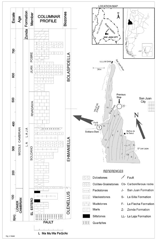
Figure 2. Geology of the Zonda Gulch, in Chica de Zonda Range at Eastern Precordillera.
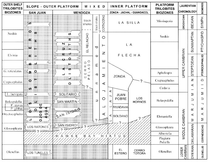
Figure 3. Stratigraphic correlation of the Cambrian of Precordillera. After Bordonaro (2003)
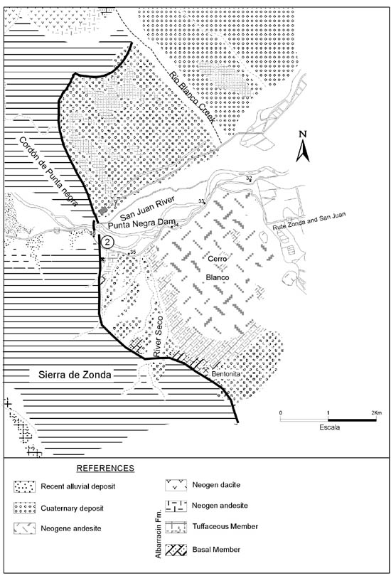
Figure 4. Geology of the Cerro Blanco (Blanco Hill) and Punta Negra Dam areas at Central Precordillera. After Leveratto (1968).
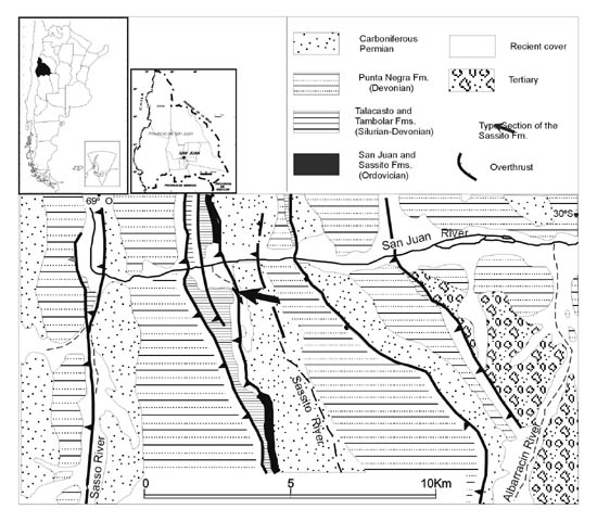
Figure 5. Geology of the Sassito Creek at Central Precordillera. After Astini & Cañas (1995)
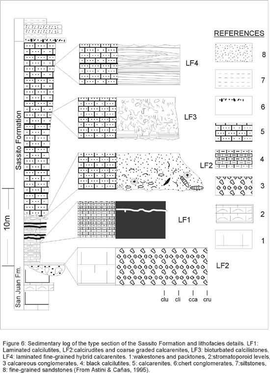
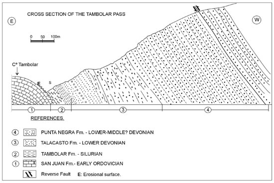
Figure 7. Stratigraphic section of the Lower Paleozoic at the Tambolar Pass, Central Precordillera. Modified from Heim (1948)
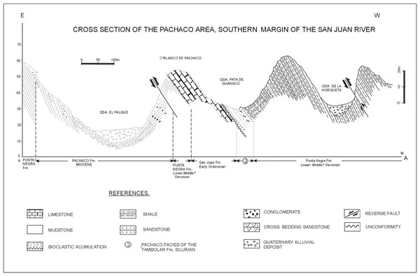
Figure 8. Stratigraphic section of the Lower Paleozoic and Neogene at the Pachaco locality. Modified from Peralta et al. (1995)
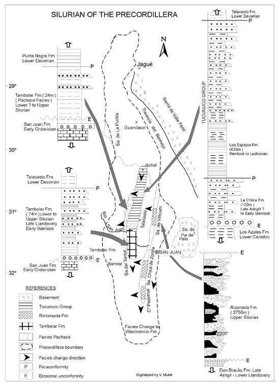
Figure 9. Geologic map showing stratigraphy and distribution of the Silurian units at Eastern and Central Precordillera. Modified from Peralta (1990).
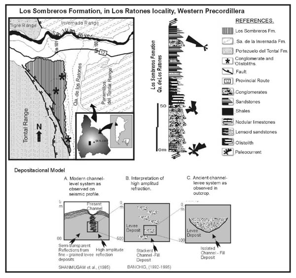
Figure 10. Geology and stratigraphy of the Ordovician Los Sombreros Formation in the Los Ratones Creek, at the eastern border of the Western Precordillera. After Banchig (1992, 1995).
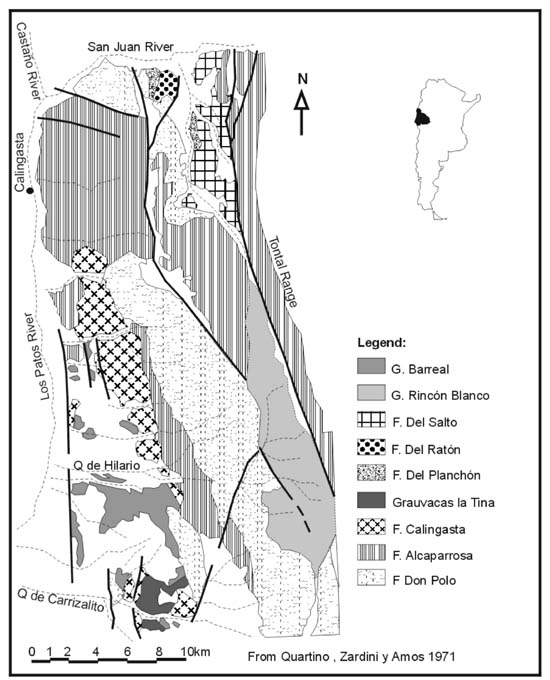
Figure 11. Geology and stratigraphy of the Lower and Upper Paleozoic, and Triassic, on the western belt of the Western Precordillera, to the south of the San Juan River. After Quartino et al. (1971).
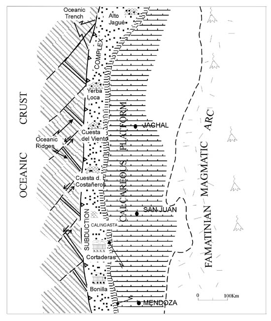
Figure 12. Geologic map of the San Juan River area, westward from the Sierra del Tontal, mainly showing the Upper Ordovician (Hirnantian) Alcaparrosa Formation outcrops and associated pillow lavas (Quartino et al., 1971). Paleogeographic and geotectonic setting of Western Precordillera, after Haller & Ramos (1984).
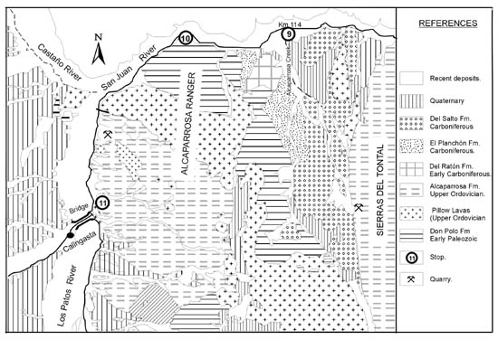
Figure 13. Distribution of the ophiolite complex along the western border of the Precordillera, from Bonilla–Cortadera area (south) in Mendoza Province, to Alto Jagüé (north) in La Rioja Province. After Quartino et al. (1971).